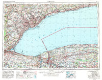
1962 Map of Toronto
USGS Topo · Published 1982About this map
Lake Ontario serves as the central focal point for this regional survey, connecting the industrial and residential corridors of Southern Ontario and Western New York. The map documents the urban expansion of Toronto and its surrounding boroughs like North York and Scarborough, where the Scarborough Bluffs line the northern shore. On the southern side of the lake, the engineering of the Welland Canal and the natural barrier of the Niagara Escarpment define the movement of goods and people between Lake Erie and the lower lakes.
Find a feature on this map
110 named features on this map. Tap any name to fly to it.
Don’t see what you’re looking for? This feature index may not catch every label — zoom into the map to look around manually.
Map Details
Editions of this 1962 Toronto Map
This is the sole edition of this map. No revisions or reprints were ever made.
Other maps of this area

1894 · Buffalo
USGS Topo · 1:62,500

1894 · Niagara Falls
USGS Topo · 1:62,500

1894 · Wilson
USGS Topo · 1:62,500

1896 · Niagara Falls
USGS Topo · 1:62,500

1897 · Tonawanda
USGS Topo · 1:62,500

1897 · Albion
USGS Topo · 1:62,500

1897 · Olcott
USGS Topo · 1:62,500

1897 · Medina
USGS Topo · 1:62,500

1897 · Lockport
USGS Topo · 1:62,500

1897 · Oak Orchard
USGS Topo · 1:62,500