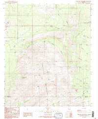
1988 Map of Tortolita Mountains
USGS Topo · Published 1989About this map
The Tortolita Mountains dominate this high-desert landscape in southern Arizona, as recorded during the late 1980s. This transitional terrain between the Pinal and Pima County line is defined by a complex network of drainage systems, including Guild Wash, Chirreon Wash, and Sausaulito Creek. These ephemeral watercourses descend from the central Falcon Divide, carving deep features like Derrio Canyon and Fresnal Canyon.
Find a feature on this map
28 named features on this map. Tap any name to fly to it.
Don’t see what you’re looking for? This feature index may not catch every label — zoom into the map to look around manually.
Map Details
Editions of this 1988 Tortolita Mountains Map
2 editions found
Other maps of this area

1904 · Tucson
USGS Topo · 1:125,000

1905 · Tucson
USGS Topo · 1:125,000

1911 · Winkelman
USGS Topo · 1:125,000

1913 · Winkelman
USGS Topo · 1:125,000

1934 · Tucson Mountains
USGS Topo · 1:125,000

1934 · Newman Peak
USGS Topo · 1:125,000

1947 · Cortaro
USGS Topo · 1:62,500

1956 · Tucson
USGS Topo · 1:250,000

1957 · Cortaro
USGS Topo · 1:62,500
1957 · Mount Lemmon
USGS Topo · 1:62,500