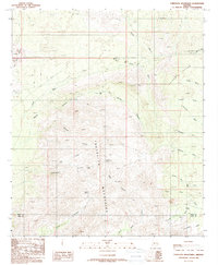
1988 Map of Tortolita Mountains
USGS Topo · Published 1989About this map
The Tortolita Mountains define this high-desert landscape as it was documented in the late 1980s. A intricate network of drainage systems, including Guild Wash, Parker Canyon Wash, and Indian Town Wash, illustrates the watershed pattern along the Falcon Divide. This survey is particularly useful for identifying vital water sources in an arid climate, marking Cottonwood Spring, Bass Spring, and Cochie Spring, which were essential for both local livestock and travelers.
Find a feature on this map
34 named features on this map. Tap any name to fly to it.
Don’t see what you’re looking for? This feature index may not catch every label — zoom into the map to look around manually.
Map Details
Editions of this 1988 Tortolita Mountains Map
2 editions found
Other maps of this area

1904 · Tucson
USGS Topo · 1:125,000

1905 · Tucson
USGS Topo · 1:125,000

1911 · Winkelman
USGS Topo · 1:125,000

1913 · Winkelman
USGS Topo · 1:125,000

1934 · Tucson Mountains
USGS Topo · 1:125,000

1934 · Newman Peak
USGS Topo · 1:125,000

1947 · Cortaro
USGS Topo · 1:62,500

1956 · Tucson
USGS Topo · 1:250,000

1957 · Cortaro
USGS Topo · 1:62,500
1957 · Mount Lemmon
USGS Topo · 1:62,500