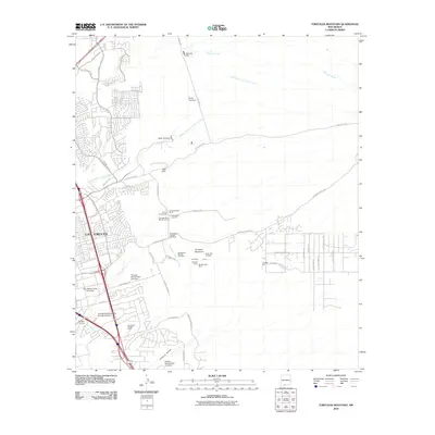
2010 Map of Tortugas Mountain
USGS Topo · Published 2010About this map
Las Cruces and the adjacent New Mexico State University campus anchor the western edge of this desert landscape, where the Chihuahuan Desert meets urban expansion. To the east, Tortugas Mountain rises as a prominent landmark, surrounded by a high concentration of mineral extraction sites including the Tortugas Mine, Santiago Mine, and Manganese Number One Mine. The terrain is deeply etched by a network of drainage channels such as Alameda Arroyo, North Fork Las Cruces Arroyo, and Fillmore Arroyo, which are managed by several flood-control structures like the North Fork Dam and Tortugas Site Number One Dam.
Find a feature on this map
56 named features on this map. Tap any name to fly to it.
Don’t see what you’re looking for? This feature index may not catch every label — zoom into the map to look around manually.
Map Details
Editions of this 2010 Tortugas Mountain Map
This is the sole edition of this map. No revisions or reprints were ever made.
Other maps of this area

1891 · Las Cruces
USGS Topo · 1:125,000

1893 · Las Cruces
USGS Topo · 1:125,000

1941 · Las Cruces
USGS Topo · 1:62,500

1941 · Organ Peak
USGS Topo · 1:62,500

1943 · La Mesa
USGS Topo · 1:62,500

1943 · Organ Peak
USGS Topo · 1:62,500

1943 · Afton
USGS Topo · 1:62,500

1943 · Las Cruces
USGS Topo · 1:62,500
1955 · Tortugas Mountain
USGS Topo · 1:24,000
1955 · Bishop Cap
USGS Topo · 1:24,000