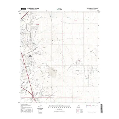
2017 Map of Tortugas Mountain
USGS Topo · Published 2017About this map
Las Cruces expansion dominates the western edge of this landscape, where suburban developments like Rinconada Blvd and Sonoma Ranch Blvd press against the high desert terrain. The area is defined by a network of drainage channels that flow from the higher elevations toward the Mesilla Valley, including the Alameda Arroyo and Tortugas Arroyo. Centrally, Tortugas Mountain stands as a prominent topographical landmark, surrounded by a complex grid of township lines such as t23s r2e. Near the southern residential fringes of University Park, the Tortugas Cem provides a point of significant local genealogical interest. The map illustrates the contemporary intersection of modern infrastructure and the natural arroyo systems that have long dictated the layout of the region.
Find a feature on this map
116 named features on this map. Tap any name to fly to it.
Don’t see what you’re looking for? This feature index may not catch every label — zoom into the map to look around manually.
Map Details
Editions of this 2017 Tortugas Mountain Map
This is the sole edition of this map. No revisions or reprints were ever made.
Other maps of this area

1891 · Las Cruces
USGS Topo · 1:125,000

1893 · Las Cruces
USGS Topo · 1:125,000

1941 · Las Cruces
USGS Topo · 1:62,500

1941 · Organ Peak
USGS Topo · 1:62,500

1943 · La Mesa
USGS Topo · 1:62,500

1943 · Organ Peak
USGS Topo · 1:62,500

1943 · Afton
USGS Topo · 1:62,500

1943 · Las Cruces
USGS Topo · 1:62,500
1955 · Tortugas Mountain
USGS Topo · 1:24,000
1955 · Bishop Cap
USGS Topo · 1:24,000