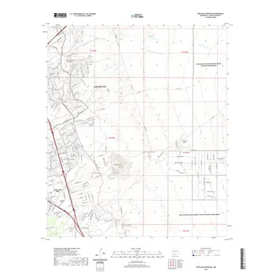
2020 Map of Tortugas Mountain
USGS Topo · Published 2020About this map
Las Cruces dominates the western portion of this landscape, showing a dense network of suburban development stretching toward the high desert. The eastern edge is defined by the Organ Mountains-Desert Peaks National Monument, where the terrain transitions into a rugged protected wilderness. A central landmark, Tortugas Mtn, rises prominently above the surrounding desert floor, hosting an Observatory and specialized infrastructure like the Geothermal Connector.
Find a feature on this map
167 named features on this map. Tap any name to fly to it.
Don’t see what you’re looking for? This feature index may not catch every label — zoom into the map to look around manually.
Map Details
Editions of this 2020 Tortugas Mountain Map
This is the sole edition of this map. No revisions or reprints were ever made.
Other maps of this area

1891 · Las Cruces
USGS Topo · 1:125,000

1893 · Las Cruces
USGS Topo · 1:125,000

1941 · Las Cruces
USGS Topo · 1:62,500

1941 · Organ Peak
USGS Topo · 1:62,500

1943 · La Mesa
USGS Topo · 1:62,500

1943 · Organ Peak
USGS Topo · 1:62,500

1943 · Afton
USGS Topo · 1:62,500

1943 · Las Cruces
USGS Topo · 1:62,500
1955 · Tortugas Mountain
USGS Topo · 1:24,000
1955 · Bishop Cap
USGS Topo · 1:24,000