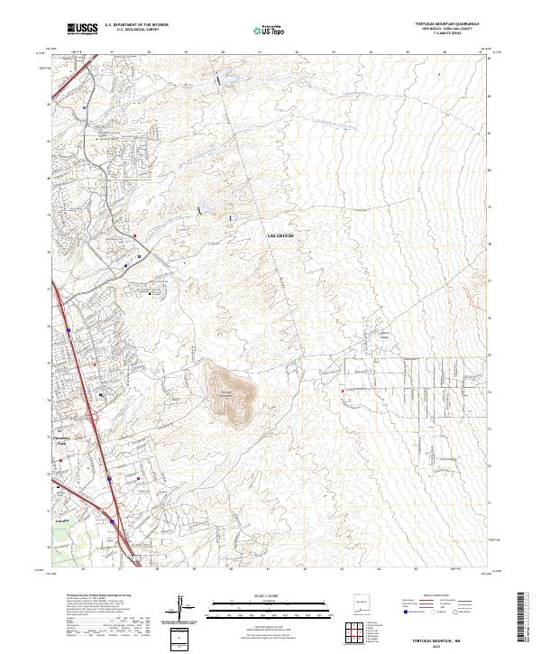
2023 Map of Tortugas Mountain
USGS Topo · Published 2023About this map
Tortugas Mountain rises as a prominent landmark on the eastern edge of the Mesilla Valley, anchoring a landscape where desert arroyos and modern residential growth converge. The map documents the eastern expansion of Las Cruces, showing a dense network of suburban streets such as Morningstar Dr and Rinconada Blvd pushing toward the base of the mountain. Cultural sites are clearly noted, including the historic Tortugas Cem and Dios Cem, which provide essential points of reference for local genealogy and history.
Find a feature on this map
178 named features on this map. Tap any name to fly to it.
Don’t see what you’re looking for? This feature index may not catch every label — zoom into the map to look around manually.
Map Details
Editions of this 2023 Tortugas Mountain Map
This is the sole edition of this map. No revisions or reprints were ever made.
Other maps of this area

1891 · Las Cruces
USGS Topo · 1:125,000

1893 · Las Cruces
USGS Topo · 1:125,000

1941 · Las Cruces
USGS Topo · 1:62,500

1941 · Organ Peak
USGS Topo · 1:62,500

1943 · La Mesa
USGS Topo · 1:62,500

1943 · Organ Peak
USGS Topo · 1:62,500

1943 · Afton
USGS Topo · 1:62,500

1943 · Las Cruces
USGS Topo · 1:62,500
1955 · Tortugas Mountain
USGS Topo · 1:24,000
1955 · Bishop Cap
USGS Topo · 1:24,000