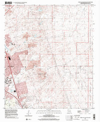
1996 Map of Tortugas Mountain
USGS Topo · Published 2002About this map
Las Cruces dominates the western edge of this desert landscape, where urban development meets the significant relief of Tortugas Mountain. The area is defined by its complex water management system, featuring the Alameda Dam, North Fork Dam, and South Fork Dam which control the ephemeral flows of the Alameda Arroyo and Tortugas Arroyo. To the east, the terrain rises sharply into the Organ Mountains Recreation Area, a region marked by steep canyons and mining history, including the Standard Mine. The presence of the New Mexico State Univ campus and several residential developments like the Colony and Mesilla Civil Colony highlights the late 20th-century growth of this university city. Infrastructure such as the Las Cruces Lateral and roads like Dripping Springs Road provide a clear view of how the city integrated with the surrounding arid topography.
Find a feature on this map
30 named features on this map. Tap any name to fly to it.
Don’t see what you’re looking for? This feature index may not catch every label — zoom into the map to look around manually.
Map Details
Editions of this 1996 Tortugas Mountain Map
This is the sole edition of this map. No revisions or reprints were ever made.
Other maps of this area

1891 · Las Cruces
USGS Topo · 1:125,000

1893 · Las Cruces
USGS Topo · 1:125,000

1941 · Las Cruces
USGS Topo · 1:62,500

1941 · Organ Peak
USGS Topo · 1:62,500

1943 · La Mesa
USGS Topo · 1:62,500

1943 · Organ Peak
USGS Topo · 1:62,500

1943 · Afton
USGS Topo · 1:62,500

1943 · Las Cruces
USGS Topo · 1:62,500
1955 · Tortugas Mountain
USGS Topo · 1:24,000
1955 · Bishop Cap
USGS Topo · 1:24,000