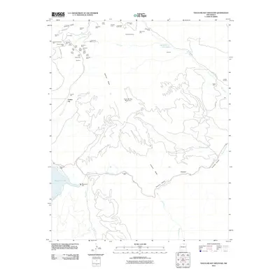
2010 Map of Touch-Me-Not Mountain
USGS Topo · Published 2010About this map
Virginia City and a dense network of high-altitude gold and silver claims define this portion of the Cimarron Range in northern New Mexico. The map reveals an intensive history of extraction, with dozens of named sites like the Montezuma Mine, Showman Mine, and Rebel Chief Mine clustered along the drainages of Willow Creek and Humbug Gulch. This concentration of lode and placer claims suggests the enduring legacy of the Moreno Valley's mining era, which fueled the development of early settlements in the shadow of Touch-Me-Not Mountain.
Find a feature on this map
55 named features on this map. Tap any name to fly to it.
Don’t see what you’re looking for? This feature index may not catch every label — zoom into the map to look around manually.
Map Details
Editions of this 2010 Touch-Me-Not Mountain Map
This is the sole edition of this map. No revisions or reprints were ever made.
Other maps of this area

1954 · Raton
USGS Topo · 1:250,000

1955 · Ute Park
USGS Topo · 1:62,500

1956 · Tooth Of Time
USGS Topo · 1:62,500

1958 · Raton
USGS Topo · 1:250,000

1963 · Eagle Nest
USGS Topo · 1:24,000

1963 · Red River Pass
USGS Topo · 1:24,000

1965 · Palo Flechado Pass
USGS Topo · 1:24,000

1982 · Wheeler Peak
USGS Topo · 1:100,000

1983 · Taos
USGS Topo · 1:100,000
1987 · Ute Park
USGS Topo · 1:24,000