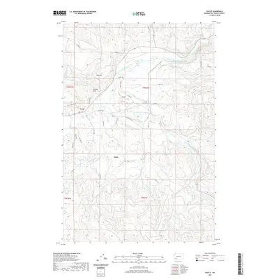
2020 Map of Toutle
USGS Topo · Published 2020About this map
Toutle and the settlement of Sightly are centered in this survey of the Cowlitz County landscape, where the confluence of the North Fork Toutle River and South Fork Toutle River shapes the local topography. The map illustrates a network of drainage systems feeding these primary forks, including Studebaker Cr, Hemlock Cr, and Outlet Cr. The elevation is punctuated by Beigle Mtn, while the built environment is largely defined by rural road networks like S Toutle Rd and Sightly Rd. A notable crossing is found at the Coal Bank Bridge over the North Fork, reflecting the historical infrastructure used to navigate this water-rich timber and mountain country. The terrain transition between these river valleys and the rising peaks highlights the persistent natural boundaries that dictate settlement patterns in this part of Washington.
Find a feature on this map
42 named features on this map. Tap any name to fly to it.
Don’t see what you’re looking for? This feature index may not catch every label — zoom into the map to look around manually.
Map Details
Editions of this 2020 Toutle Map
This is the sole edition of this map. No revisions or reprints were ever made.
Other maps of this area

1921 · Kalama
USGS Topo · 1:62,500

1941 · Olequa
USGS Topo · 1:62,500

1942 · Toutle
USGS Topo · 1:62,500

1943 · Pigeon Springs
USGS Topo · 1:62,500

1953 · Hoquiam
USGS Topo · 1:250,000

1953 · Toutle
USGS Topo · 1:62,500

1953 · Castle Rock
USGS Topo · 1:62,500

1953 · Mt. Brynion
USGS Topo · 1:24,000

1953 · Pigeon Springs
USGS Topo · 1:62,500

1957 · Hoquiam
USGS Topo · 1:250,000