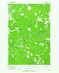
1953 Map of Toutle
USGS Topo · Published 1964About this map
Cowlitz Prairie and Layton Prairie dominate the northwestern landscape of this 1953 survey, where agricultural clearings meet the dense timberlands of the Cascade foothills. The region's economy is defined by industrial forestry and resource management, evidenced by the extensive network of Logging Roads and Private Roads traversing the drainages of the Green River and South Fork Toutle River. Significant infrastructure for the era includes the Green River Salmon Hatchery and the Toutle Lake School, which served the scattered settlements of Toutle, Kid Valley, and Salmon Valley. From the Windom Mine to the timber outpost at Camp Baker, the map documents a working landscape before modern eruptions altered the river systems. Geologists and local historians can trace the original paths of Cedar Creek and Winston Creek alongside landmarks like the Coal Bank Bridge.
Find a feature on this map
69 named features on this map. Tap any name to fly to it.
Don’t see what you’re looking for? This feature index may not catch every label — zoom into the map to look around manually.
Map Details
Editions of this 1953 Toutle Map
Other maps of this area

1916 · Chehalis
USGS Topo · 1:125,000

1919 · Mount St Helens
USGS Topo · 1:125,000

1921 · Kalama
USGS Topo · 1:62,500

1937 · Eatonville
USGS Topo · 1:125,000

1941 · Olequa
USGS Topo · 1:62,500

1942 · Toutle
USGS Topo · 1:62,500

1943 · Willapa
USGS Topo · 1:62,500

1943 · Pigeon Springs
USGS Topo · 1:62,500

1953 · Hoquiam
USGS Topo · 1:250,000

1953 · Toutle
USGS Topo · 1:62,500