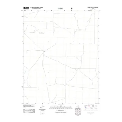
2010 Map of Tovrea Ranch
USGS Topo · Published 2010About this map
Tovrea Ranch serves as the primary landmark in this corner of Dallam County, situated amidst the high plains of the Texas Panhandle. The landscape is defined by the ephemeral path of Rita Blanca Creek, which winds through the western portion of the quadrangle. Local transportation is facilitated by rural routes such as O Bar Ln and Shirey Rd, reflecting the ranching infrastructure and large-tract land use characteristic of the region. This 2010 survey provides a detailed look at the water features and drainage patterns that dictate the rhythm of life in this semi-arid environment, where named ranching outposts often represent the only significant human settlements for miles.
Find a feature on this map
4 named features on this map. Tap any name to fly to it.
Don’t see what you’re looking for? This feature index may not catch every label — zoom into the map to look around manually.
Map Details
Editions of this 2010 Tovrea Ranch Map
This is the sole edition of this map. No revisions or reprints were ever made.
Other maps of this area

1954 · Dalhart
USGS Topo · 1:250,000

1958 · Dalhart
USGS Topo · 1:250,000

1962 · Dalhart
USGS Topo · 1:250,000

1973 · Buffalo Springs
USGS Topo · 1:24,000

1973 · Wharton Ranch
USGS Topo · 1:24,000

1973 · Tovrea Ranch
USGS Topo · 1:24,000

1973 · Perico
USGS Topo · 1:24,000

1973 · Bolin NE
USGS Topo · 1:24,000

1973 · Bolin
USGS Topo · 1:24,000
1973 · Coldwater West
USGS Topo · 1:24,000