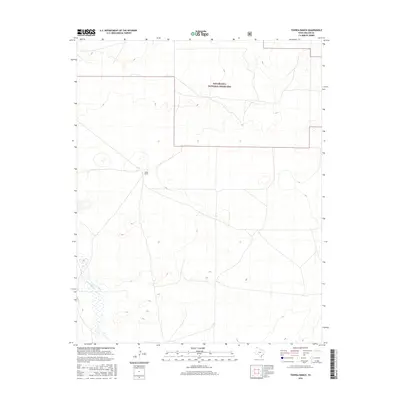
2016 Map of Tovrea Ranch
USGS Topo · Published 2016About this map
Rita Blanca National Grassland dominates the northern landscape of this Dallam County region, preserving a significant portion of the High Plains shortgrass prairie. This survey captures a corner of the Panhandle defined by expansive open range and intermittent watercourses, most notably the winding path of Rita Blanca Cr in the southwest. The Tovrea Ranch serves as a primary marker of the area's continued ranching heritage, situated amidst a grid of local roads and sections that reflect the late 20th-century land management patterns. While primarily a landscape of conservation and cattle, the terrain's gentle contours reveal the subtle drainage systems that have shaped the cattle industry in this corner of the Texas Panhandle.
Find a feature on this map
3 named features on this map. Tap any name to fly to it.
Don’t see what you’re looking for? This feature index may not catch every label — zoom into the map to look around manually.
Map Details
Editions of this 2016 Tovrea Ranch Map
This is the sole edition of this map. No revisions or reprints were ever made.
Other maps of this area

1954 · Dalhart
USGS Topo · 1:250,000

1958 · Dalhart
USGS Topo · 1:250,000

1962 · Dalhart
USGS Topo · 1:250,000

1973 · Buffalo Springs
USGS Topo · 1:24,000

1973 · Wharton Ranch
USGS Topo · 1:24,000

1973 · Tovrea Ranch
USGS Topo · 1:24,000

1973 · Perico
USGS Topo · 1:24,000

1973 · Bolin NE
USGS Topo · 1:24,000

1973 · Bolin
USGS Topo · 1:24,000
1973 · Coldwater West
USGS Topo · 1:24,000