
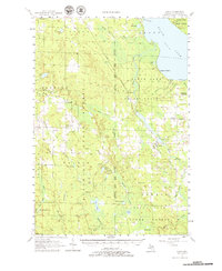
1957 Map of Tower
USGS Topo · Published 1968About this map
Tower and its surrounding timberlands and waterways define this mid-century portrait of northern Cheboygan County. The industrial and natural landscape is anchored by the Detroit And Mackinac railroad line, which facilitated transport through the Black Lake State Forest and Hardwood State Forest. Water management is a central theme, evidenced by the Gaging Station Kleber Dam on the Black River and the presence of Tower Pond.
Find a feature on this map
66 named features on this map. Tap any name to fly to it.
Don’t see what you’re looking for? This feature index may not catch every label — zoom into the map to look around manually.
Map Details
Editions of this 1957 Tower Map
3 editions found
Other maps of this area

1954 · Gaylord
USGS Topo · 1:62,500

1954 · Hetherton
USGS Topo · 1:62,500

1955 · Atlanta
USGS Topo · 1:62,500

1955 · Cheboygan
USGS Topo · 1:250,000

1957 · Tower
USGS Topo · 1:62,500

1957 · Wolverine
USGS Topo · 1:62,500

1957 · Cheboygan
USGS Topo · 1:62,500

1957 · Mullett Lake
USGS Topo · 1:62,500

1957 · Onaway
USGS Topo · 1:62,500

1958 · Cheboygan
USGS Topo · 1:250,000