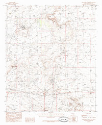
1985 Map of Tower Hill North
USGS Topo · Published 1985About this map
Nimenim Ridge and Clayton Basin define this landscape in the mid-1980s, revealing an arid New Mexico environment heavily shaped by industrial extraction. The area serves as a significant hub for petroleum production, with an extensive Gas Field and Oil Field covering the eastern terrain. This provisional survey captures the intersection of natural topography and utility, where an Aqueduct traverses the northern reaches and an Old Railroad Grade runs alongside the ridge, marking a previous era of transport.
Find a feature on this map
19 named features on this map. Tap any name to fly to it.
Don’t see what you’re looking for? This feature index may not catch every label — zoom into the map to look around manually.
Map Details
Editions of this 1985 Tower Hill North Map
This is the sole edition of this map. No revisions or reprints were ever made.
Other maps of this area

1939 · Carlsbad
USGS Topo · 1:62,500

1939 · Nash Draw
USGS Topo · 1:62,500

1942 · Clayton Basin
USGS Topo · 1:62,500

1943 · Carlsbad
USGS Topo · 1:62,500

1943 · Clayton Basin
USGS Topo · 1:62,500

1943 · Oil City
USGS Topo · 1:62,500

1943 · Nash Draw
USGS Topo · 1:62,500

1954 · Carlsbad
USGS Topo · 1:250,000

1954 · Hobbs
USGS Topo · 1:250,000

1958 · Carlsbad
USGS Topo · 1:250,000