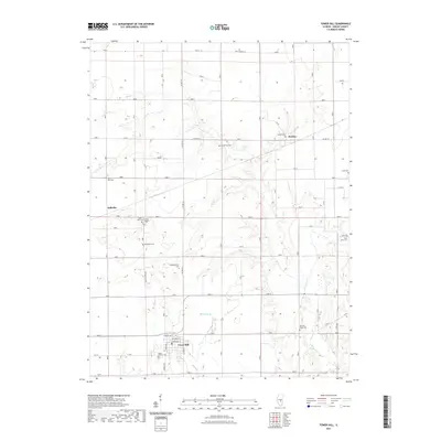
2021 Map of Tower Hill
USGS Topo · Published 2021About this map
Tower Hill serves as the primary hub of this Shelby County landscape, where the local street grid including Bissell St and Fillmore St meets the rural road network. The terrain is defined by the branching tributaries of Mud Cr and Robinson Cr, which carve through the agricultural fields that dominate the region. This 2021 topographic record reveals a dense concentration of cemeteries and rural religious sites, suggesting a long history of family homesteads and established community roots. Small settlements like Dollville and Henton are situated near several family and community burial grounds, including the Middlesworth Cem and Armstrong Cem. The map provides a detailed view of the infrastructure supporting these rural townships, from the alignment of Co Hwy 16 to the quiet reach of Knobs Church Rd, making it an essential resource for those documenting the genealogy and development of this Illinois prairie region.
Find a feature on this map
27 named features on this map. Tap any name to fly to it.
Don’t see what you’re looking for? This feature index may not catch every label — zoom into the map to look around manually.
Map Details
Editions of this 2021 Tower Hill Map
This is the sole edition of this map. No revisions or reprints were ever made.
Other maps of this area

1942 · Shelbyville
USGS Topo · 1:62,500

1946 · Shelbyville
USGS Topo · 1:62,500

1947 · Pana
USGS Topo · 1:62,500

1949 · Dalton City
USGS Topo · 1:62,500

1949 · Pana
USGS Topo · 1:62,500

1952 · Assumption
USGS Topo · 1:62,500

1958 · Decatur
USGS Topo · 1:250,000

1961 · Decatur
USGS Topo · 1:250,000
1981 · Fancher
USGS Topo · 1:24,000
1981 · Shelbyville
USGS Topo · 1:24,000