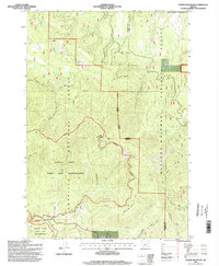
1995 Map of Tower Mountain
USGS Topo · Published 1998About this map
Tower Mountain serves as the focal point for this section of the Blue Mountains, topped by the Tower Mountain Lookout within the boundaries of the Umatilla National Forest. The landscape is defined by the high-elevation drainage systems of Cable Creek and the North Fork John Day River, which carve through the North Fork John Day Wilderness. In the mid-1990s, this area remained largely inaccessible by modern roads, instead relying on an extensive network of pack trails such as the Hidaway Meadows Trail and the Winom Trail.
Find a feature on this map
35 named features on this map. Tap any name to fly to it.
Don’t see what you’re looking for? This feature index may not catch every label — zoom into the map to look around manually.
Map Details
Editions of this 1995 Tower Mountain Map
This is the sole edition of this map. No revisions or reprints were ever made.
Other maps of this area

1901 · Sumpter
USGS Topo · 1:125,000

1951 · Desolation Butte
USGS Topo · 1:62,500

1953 · Pendleton
USGS Topo · 1:250,000

1955 · Canyon City
USGS Topo · 1:250,000

1956 · Pendleton
USGS Topo · 1:250,000

1959 · Canyon City
USGS Topo · 1:250,000

1965 · Marley Creek
USGS Topo · 1:24,000

1965 · Fly Valley
USGS Topo · 1:24,000

1967 · Tower Mtn
USGS Topo · 1:24,000

1967 · Sullivan Gulch
USGS Topo · 1:24,000