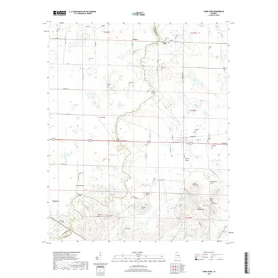
2018 Map of Town Creek
USGS Topo · Published 2018About this map
Town Creek serves as the central hub of this North Alabama landscape, situated at the junction of the railroad and the Alt 72 corridor. The map reveals a high density of family and community burial grounds, such as Elmwood Cem, Abernathy Cem, and Scruggs Cem, reflecting deep-rooted generational ties to the land. This agricultural and wooded area is defined by its complex water network, where Fluitt Creek and the Boatwright Slough meander through the Big Bend area. To the south, the topography transitions into more prominent peaks like Patrick Mtn and Brooks Spring Mtn. Historical crossings such as Pruett Bridge and King Bridge connect the smaller settlements of Cottontown and Midway to the larger transportation veins, illustrating the layout of rural Colbert and Lawrence counties in the late 2010s.
Find a feature on this map
110 named features on this map. Tap any name to fly to it.
Don’t see what you’re looking for? This feature index may not catch every label — zoom into the map to look around manually.
Map Details
Editions of this 2018 Town Creek Map
This is the sole edition of this map. No revisions or reprints were ever made.
Other maps of this area

1914 · Rogersville
USGS Topo · 1:48,000

1914 · Muscle Shoals
USGS Topo · 1:48,000

1916 · Muscle Shoals
USGS Topo · 1:62,500

1916 · Rogersville
USGS Topo · 1:62,500

1924 · Tuscumbia
USGS Topo · 1:48,000

1926 · Tuscumbia
USGS Topo · 1:62,500

1936 · Thorntontown
USGS Topo · 1:24,000

1936 · Courtland
USGS Topo · 1:24,000

1936 · Wheeler Dam
USGS Topo · 1:24,000

1936 · Town Creek
USGS Topo · 1:24,000