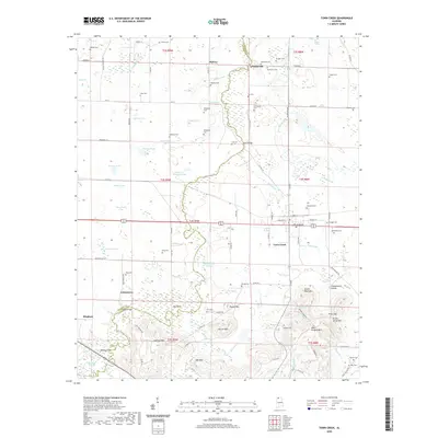
2020 Map of Town Creek
USGS Topo · Published 2020About this map
The town of Town Creek serves as the central hub of this northern Alabama landscape, situated where the Colbert Co and Lawrence Co line meets the rail corridor. This modern survey reveals a dense concentration of historical family markers and community sites, reflecting generations of settlement along the waterways. To the south, the terrain rises into several named peaks including Jeffreys Mtn, Patrick Mtn, and Green Bluff Mtn, while the eponymous Town Creek winds north toward the Tennessee River valley. Numerous small ponds and sloughs like Mississippi Pond and Boatwright Slough dot the lowlands, indicating the region's complex hydrology. Genealogists will find an exceptional number of small burial grounds, from the Stanley and Bethel cemeteries in the north to the Lansdell and Bain cemeteries further south, providing a detailed record of the families who established the communities of Cottontown, Midway, and Lennon Hill.
Find a feature on this map
114 named features on this map. Tap any name to fly to it.
Don’t see what you’re looking for? This feature index may not catch every label — zoom into the map to look around manually.
Map Details
Editions of this 2020 Town Creek Map
This is the sole edition of this map. No revisions or reprints were ever made.
Other maps of this area

1914 · Rogersville
USGS Topo · 1:48,000

1914 · Muscle Shoals
USGS Topo · 1:48,000

1916 · Muscle Shoals
USGS Topo · 1:62,500

1916 · Rogersville
USGS Topo · 1:62,500

1924 · Tuscumbia
USGS Topo · 1:48,000

1926 · Tuscumbia
USGS Topo · 1:62,500

1936 · Thorntontown
USGS Topo · 1:24,000

1936 · Courtland
USGS Topo · 1:24,000

1936 · Wheeler Dam
USGS Topo · 1:24,000

1936 · Town Creek
USGS Topo · 1:24,000