1968 Map of Towner
USGS Topo · Published 1971About this map
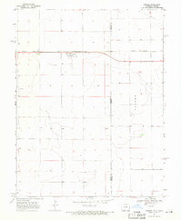
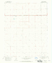
The High Plains borderlands between Kiowa County, Colorado, and Greeley County, Kansas, are defined by the intersection of rail transit and agricultural utility. Towner serves as the primary hub for this arid stretch, organized around the Missouri Pacific railroad line that cuts horizontally across the landscape. The infrastructure of the late 1960s is represented by a prominent Radio Tower and a deep Well near the town site, reflecting the critical importance of communication and water management in this prairie environment. Just to the south of the settlement, the Towner Cem provides a genealogical touchpoint for local families. Further east, the small settlement of Colokan sits directly on the state line, its name a literal portmanteau of the two bordering states, Colorado and Kansas.
Find a feature on this map
10 named features on this map. Tap any name to fly to it.
Don’t see what you’re looking for? This feature index may not catch every label — zoom into the map to look around manually.
Map Details
Editions of this 1968 Towner Map
This is the sole edition of this map. No revisions or reprints were ever made.
Other maps of this area

1890 · Granada
USGS Topo · 1:125,000

1892 · Cheyenne Wells
USGS Topo · 1:125,000
1892 · Granada
USGS Topo · 1:125,000
1894 · Cheyenne Wells
USGS Topo · 1:125,000
1894 · Granada
USGS Topo · 1:125,000

1954 · Lamar
USGS Topo · 1:250,000

1955 · Scott City
USGS Topo · 1:250,000

1958 · Lamar
USGS Topo · 1:250,000

1958 · Scott City
USGS Topo · 1:250,000
1968 · Stuart
USGS Topo · 1:24,000