
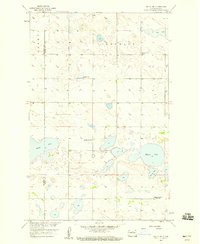
1954 Map of Towner SE
USGS Topo · Published 1956About this map
Berwick stands as the primary settlement in this section of the prairie, situated at a vital junction of the Great Northern railroad line. The map highlights the agricultural and transport infrastructure of the mid-1950s, documenting a landscape shaped by the development of the Missouri River Basin. The terrain transitions between the Berwick and Gorman regions, characterized by numerous small depressions and ponds typical of the North Dakota pothole region. For genealogists, the inclusion of the Berwick Cem and the precise boundary line between Pierce Co and Mc Henry Co provides essential spatial context for family records and land ownership from this era.
Find a feature on this map
7 named features on this map. Tap any name to fly to it.
Don’t see what you’re looking for? This feature index may not catch every label — zoom into the map to look around manually.
Map Details
Editions of this 1954 Towner SE Map
This is the sole edition of this map. No revisions or reprints were ever made.
Other maps of this area

1950 · Towner NW
USGS Topo · 1:24,000

1950 · Towner
USGS Topo · 1:24,000

1954 · Towner NE
USGS Topo · 1:24,000

1954 · Berwick
USGS Topo · 1:24,000

1954 · Round Lake
USGS Topo · 1:24,000

1954 · Minot
USGS Topo · 1:250,000

1955 · Rangeley NW
USGS Topo · 1:24,000

1955 · Rangeley NE
USGS Topo · 1:24,000

1958 · Minot
USGS Topo · 1:250,000
1958 · Balta NW
USGS Topo · 1:24,000