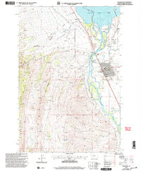
2001 Map of Townsend
USGS Topo · Published 2004About this map
The Missouri River corridor near the turn of the 21st century is defined by its industrial and agricultural balance, centered on the community of Townsend. This 2001 revision illustrates a landscape heavily utilized for resource extraction, with numerous prospects, a quarry, and mine shafts scattered through the Limestone Hills and Little Hogback to the west. Evidence of historical mining activity is further seen in tailings near Kalamazoo Gulch and the Whipcracker area.
Find a feature on this map
31 named features on this map. Tap any name to fly to it.
Don’t see what you’re looking for? This feature index may not catch every label — zoom into the map to look around manually.
Map Details
Editions of this 2001 Townsend Map
This is the sole edition of this map. No revisions or reprints were ever made.
Other maps of this area

1886 · Fort Logan
USGS Topo · 1:250,000

1948 · White Sulphur Springs
USGS Topo · 1:250,000

1949 · Radersburg
USGS Topo · 1:62,500

1949 · Toston
USGS Topo · 1:62,500

1950 · Townsend
USGS Topo · 1:62,500

1950 · Duck Creek Pass
USGS Topo · 1:62,500

1958 · White Sulphur Springs
USGS Topo · 1:250,000

1961 · White Sulphur Springs
USGS Topo · 1:250,000

1965 · White Sulphur Springs
USGS Topo · 1:250,000

1976 · Townsend
USGS Topo · 1:100,000