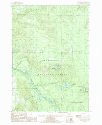
1987 Map of Townsend Lake
USGS Topo · Published 1987About this map
The Pere Marquette River defines the southern reach of this landscape, meandering through the heart of the Manistee National Forest. This 1980s-era study captures a region defined by its numerous glacial lakes and riparian systems, where small settlements like Wingleton and Kinney sit near the water's edge. Local history is anchored by a Cem located near Pine Island Lake, while the eastern portion of the sheet shows a dense concentration of water bodies including Railroad Lake, Feeder Lake, and the namesake Townsend Lake. The landscape transition from the wet lowlands of Carpenter Marsh to the timbered tracts of Sweetwater and Webber townships illustrates a wilderness area maintained for conservation and recreation, evidenced by the Roadside Park and Boat Ramp facilities.
Find a feature on this map
31 named features on this map. Tap any name to fly to it.
Don’t see what you’re looking for? This feature index may not catch every label — zoom into the map to look around manually.
Map Details
Editions of this 1987 Townsend Lake Map
This is the sole edition of this map. No revisions or reprints were ever made.
Other maps of this area

1931 · Baldwin NW
USGS Topo · 1:31,680

1931 · Custer NE
USGS Topo · 1:31,680

1931 · Baldwin NE
USGS Topo · 1:31,680

1931 · Custer SE
USGS Topo · 1:31,680

1932 · Freesoil SE
USGS Topo · 1:31,680

1933 · Peacock SE
USGS Topo · 1:31,680

1933 · Peacock SW
USGS Topo · 1:31,680

1954 · Traverse City
USGS Topo · 1:250,000

1954 · Milwaukee
USGS Topo · 1:250,000

1954 · Midland
USGS Topo · 1:250,000