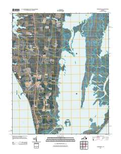
2011 Map of Townsend
USGS Topo · Published 2011About this map
Mockhorn Channel and Magothy Bay dominate the eastern reaches of this coastal landscape, where a complex network of marshes and tidal thoroughfares separates the mainland from Smith Island. The southern tip of the Delmarva Peninsula exhibits a pattern of linear settlement along the historic Route 13 corridor, connecting communities such as Townsend, Capeville, and Cheapside. This coastal geography is defined by its interface with the water, marked by numerous small landings and wharves like Bulls Landing, Arlington Wharf, and Steelmans Landing that suggest a long history of maritime commerce and local transit. Near the shoreline of Chesapeake Bay, features like Kiptopeke Beach and Butlers Bluff offer a look at the peninsula's natural edge, while inland, the Latimer Siding and Bull Farm Airport indicate the integration of rail and light aviation into the agricultural economy.
Find a feature on this map
58 named features on this map. Tap any name to fly to it.
Don’t see what you’re looking for? This feature index may not catch every label — zoom into the map to look around manually.
Map Details
Editions of this 2011 Townsend Map
This is the sole edition of this map. No revisions or reprints were ever made.
Other maps of this area

1942 · Cheriton
USGS Topo · 1:24,000

1942 · Cobb Island
USGS Topo · 1:24,000

1943 · Elliots Creek
USGS Topo · 1:25,000

1943 · Townsend
USGS Topo · 1:24,000

1943 · Richmond
USGS Topo · 1:250,000

1946 · Eastville
USGS Topo · 1:250,000

1948 · Cape Charles
USGS Topo · 1:24,000

1949 · Richmond
USGS Topo · 1:250,000
1953 · Ship Shoal Inlet
USGS Topo · 1:24,000
1955 · Elliotts Creek
USGS Topo · 1:24,000