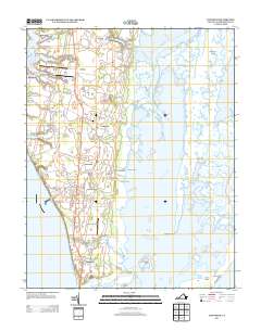
2013 Map of Townsend
USGS Topo · Published 2013About this map
Kiptopeke State Park and the surrounding coastline of Northampton County reveal a landscape shaped by both the Atlantic and the Chesapeake. The southern tip of the Delmarva Peninsula is characterized by a series of tidal channels and islands, such as Mockhorn Island and Skidmore Island, which separate the mainland from the open sea. Inland, the settlement pattern centers on the Lankford Hwy corridor, connecting historic communities like Townsend and Dalbys with the coastal fishing and farming outposts of Bulls Landing and Magotha.
Find a feature on this map
107 named features on this map. Tap any name to fly to it.
Don’t see what you’re looking for? This feature index may not catch every label — zoom into the map to look around manually.
Map Details
Editions of this 2013 Townsend Map
This is the sole edition of this map. No revisions or reprints were ever made.
Other maps of this area

1942 · Cheriton
USGS Topo · 1:24,000

1942 · Cobb Island
USGS Topo · 1:24,000

1943 · Elliots Creek
USGS Topo · 1:25,000

1943 · Townsend
USGS Topo · 1:24,000

1943 · Richmond
USGS Topo · 1:250,000

1946 · Eastville
USGS Topo · 1:250,000

1948 · Cape Charles
USGS Topo · 1:24,000

1949 · Richmond
USGS Topo · 1:250,000
1953 · Ship Shoal Inlet
USGS Topo · 1:24,000
1955 · Elliotts Creek
USGS Topo · 1:24,000