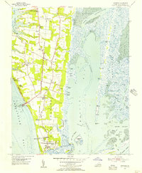
1955 Map of Townsend
USGS Topo · Published 1957About this map
The southern tip of the Delmarva Peninsula is defined here by its strategic coastal position and maritime industry in the mid-1950s. The presence of the Cape Charles Air Force Base at the terminus of the peninsula highlights the Cold War-era military importance of this land overlooking the Chesapeake Bay. The map documents a rural landscape where agriculture meets the sea, evidenced by several wharves such as Arlington Wharf and Hunts Wharf, alongside numerous landings like Steelmans Landing and Walls Landing. Small settlements and local landmarks like Townsend, Cheapside, and Lower Northampton Ch are connected by the Pennsylvania railroad line, which includes the Latimer Siding. To the east, the complex salt marsh environment of Magothy Bay and Mockhorn Island reveals a landscape dominated by tidal channels and thorofares, including The Narrows and Stringers Ditch, vital for local navigation.
Find a feature on this map
67 named features on this map. Tap any name to fly to it.
Don’t see what you’re looking for? This feature index may not catch every label — zoom into the map to look around manually.
Map Details
Editions of this 1955 Townsend Map
This is the sole edition of this map. No revisions or reprints were ever made.
Other maps of this area

1942 · Cheriton
USGS Topo · 1:24,000

1942 · Cobb Island
USGS Topo · 1:24,000

1943 · Elliots Creek
USGS Topo · 1:25,000

1943 · Townsend
USGS Topo · 1:24,000

1943 · Richmond
USGS Topo · 1:250,000

1946 · Eastville
USGS Topo · 1:250,000

1948 · Cape Charles
USGS Topo · 1:24,000

1949 · Richmond
USGS Topo · 1:250,000
1953 · Ship Shoal Inlet
USGS Topo · 1:24,000
1955 · Elliotts Creek
USGS Topo · 1:24,000