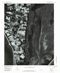
1977 Map of Townsend
USGS Topo · Published 1982About this map
Townsend and the surrounding agricultural landscape of Northampton County are captured in this 1977 orthophotograph, showing the peninsula's narrow profile between the Chesapeake Bay and the Atlantic Ocean. The aerial imagery reveals a mosaic of cultivated fields and wooded windbreaks characteristic of the Eastern Shore, clustered around small hubs like Cape Center, Cheapside, and Kiptopeke. The eastern half of the map is dominated by the intricate salt marshes and tidal channels of Mockhorn Bay, Magothy Bay, and South Bay, protected from the open ocean by a complex network of barrier islands and inlets. This aerial perspective, prepared in cooperation with the Soil Conservation Service, provides a clear record of coastal land use and the tidal geography of Old Plantation Creek during the late 1970s.
Find a feature on this map
10 named features on this map. Tap any name to fly to it.
Don’t see what you’re looking for? This feature index may not catch every label — zoom into the map to look around manually.
Map Details
Editions of this 1977 Townsend Map
This is the sole edition of this map. No revisions or reprints were ever made.
Other maps of this area

1942 · Cheriton
USGS Topo · 1:24,000

1942 · Cobb Island
USGS Topo · 1:24,000

1943 · Elliots Creek
USGS Topo · 1:25,000

1943 · Townsend
USGS Topo · 1:24,000

1943 · Richmond
USGS Topo · 1:250,000

1946 · Eastville
USGS Topo · 1:250,000

1948 · Cape Charles
USGS Topo · 1:24,000

1949 · Richmond
USGS Topo · 1:250,000
1953 · Ship Shoal Inlet
USGS Topo · 1:24,000
1955 · Elliotts Creek
USGS Topo · 1:24,000