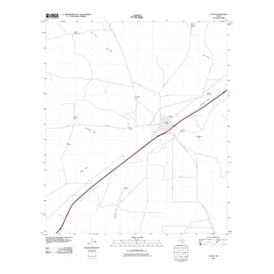
2010 Map of Toyah
USGS Topo · Published 2010About this map
The town of Toyah is the focal point of this West Texas landscape, positioned along a critical transportation corridor marked by major roads and rail lines. The local geography is defined by a series of drainage patterns, including Billingslea Draw, San Martine Draw, and Salt Draw, which dictate the placement of local infrastructure. To the southeast, Bullington Hill rises above the surrounding flats, while the town itself is served by several local thoroughfares such as S Centre St and N 4th St.
Find a feature on this map
31 named features on this map. Tap any name to fly to it.
Don’t see what you’re looking for? This feature index may not catch every label — zoom into the map to look around manually.
Map Details
Editions of this 2010 Toyah Map
This is the sole edition of this map. No revisions or reprints were ever made.
Other maps of this area

1921 · Toyah
USGS Topo · 1:125,000

1954 · Pecos
USGS Topo · 1:250,000

1955 · Saragosa
USGS Topo · 1:62,500

1957 · Pecos
USGS Topo · 1:250,000

1970 · Hermosa SW
USGS Topo · 1:24,000

1970 · Florenzo Hill
USGS Topo · 1:24,000

1970 · Big Hill
USGS Topo · 1:24,000

1970 · Toyah
USGS Topo · 1:24,000
1970 · Hermosa
USGS Topo · 1:24,000
1970 · Gozar
USGS Topo · 1:24,000