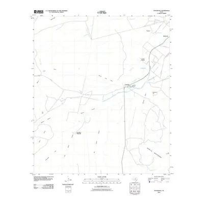
2010 Map of Toyahvale
USGS Topo · Published 2010About this map
Toyahvale and the northern edge of the Barilla Mountains define this West Texas landscape, where life is centered on the vital waters of the Trans-Pecos. The map documents a sophisticated irrigation network branching from Giffin Springs, including the Phantom Lake Canal, the Diversion Canal, and the Maincanal. These waterways distribute resources across the desert floor toward Balmorhea and Pueblo Vitoria, supporting the agricultural economy of the Toyah Creek valley.
Find a feature on this map
39 named features on this map. Tap any name to fly to it.
Don’t see what you’re looking for? This feature index may not catch every label — zoom into the map to look around manually.
Map Details
Editions of this 2010 Toyahvale Map
This is the sole edition of this map. No revisions or reprints were ever made.
Other maps of this area

1894 · Fort Davis
USGS Topo · 1:125,000

1897 · Fort Davis
USGS Topo · 1:125,000

1921 · Toyah
USGS Topo · 1:125,000

1954 · Pecos
USGS Topo · 1:250,000

1954 · Fort Stockton
USGS Topo · 1:250,000

1955 · Saragosa
USGS Topo · 1:62,500

1957 · Pecos
USGS Topo · 1:250,000

1958 · Fort Stockton
USGS Topo · 1:250,000
1970 · Sotol Hill
USGS Topo · 1:24,000
1970 · Saragosa
USGS Topo · 1:24,000