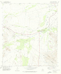
1972 Map of Toyahvale
USGS Topo · Published 1976About this map
San Solomon Creek and Toyah Creek anchor this West Texas landscape, where complex irrigation systems define the desert environment during the early 1970s. The presence of Balmorhea State Park and its surrounding springs, including Giffin Springs and Phantom Lake Spring, highlights a vital oasis culture. A sophisticated network of water infrastructure is visible, including the Main Canal, Aqueduct, and Diversion Canal, illustrating how water was managed for the settlements of Balmorhea and Toyahvale. Evidence of mid-century community life is found at the Drive-in Theater and Balmorhea Landing Strips. The map also captures the transition from the flat terrain of Augustine Flat to the rising elevations of the Barrila Mountains, crossing the boundary between Reeves and Jeff Davis Counties.
Find a feature on this map
44 named features on this map. Tap any name to fly to it.
Don’t see what you’re looking for? This feature index may not catch every label — zoom into the map to look around manually.
Map Details
Editions of this 1972 Toyahvale Map
This is the sole edition of this map. No revisions or reprints were ever made.
Other maps of this area

1894 · Fort Davis
USGS Topo · 1:125,000

1897 · Fort Davis
USGS Topo · 1:125,000

1921 · Toyah
USGS Topo · 1:125,000

1954 · Pecos
USGS Topo · 1:250,000

1954 · Fort Stockton
USGS Topo · 1:250,000

1955 · Saragosa
USGS Topo · 1:62,500

1957 · Pecos
USGS Topo · 1:250,000

1958 · Fort Stockton
USGS Topo · 1:250,000
1970 · Sotol Hill
USGS Topo · 1:24,000
1970 · Saragosa
USGS Topo · 1:24,000