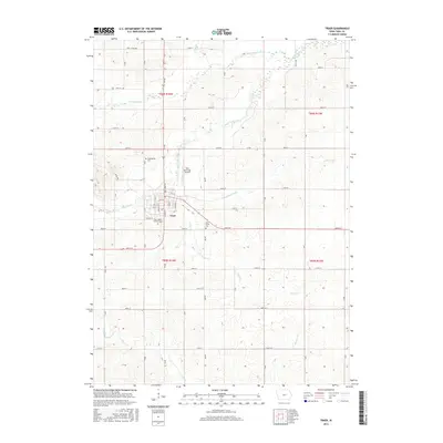
2015 Map of Traer
USGS Topo · Published 2015About this map
Traer serves as the central hub of this agricultural landscape in Tama County, characterized by a dense network of sectional roads and meandering waterways. The township layout is defined by numerous drainage systems, including Wolf Creek and Twelvemile Creek, which carve through the Iowa countryside. Cultural and genealogical markers are prominent throughout the area, notably at Buckingham Cem to the north of town and West Union Cem to the east. The local transportation infrastructure is anchored by the Traer Municipal Airport, while the religious and community history of the settlement is reflected at Saint Paul's Catholic Cem. This survey illustrates the persistent rural patterns of the region, where named branches like Little Coon Cr and Simpson Cr dictate the placement of farmstead access and regional transit routes.
Find a feature on this map
31 named features on this map. Tap any name to fly to it.
Don’t see what you’re looking for? This feature index may not catch every label — zoom into the map to look around manually.
Map Details
Editions of this 2015 Traer Map
This is the sole edition of this map. No revisions or reprints were ever made.
Other maps of this area

1954 · Waterloo
USGS Topo · 1:250,000

1955 · Waterloo
USGS Topo · 1:250,000

1963 · Buckingham
USGS Topo · 1:24,000

1963 · Eagle Center
USGS Topo · 1:24,000

1971 · Gladbrook NE
USGS Topo · 1:24,000
1971 · Elberon
USGS Topo · 1:24,000
1971 · Dysart
USGS Topo · 1:24,000

1971 · Traer
USGS Topo · 1:24,000
1971 · Clutier
USGS Topo · 1:24,000

1971 · Reinbeck
USGS Topo · 1:24,000