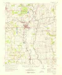
1969 Map of Tralake
USGS Topo · Published 1969About this map
Leland serves as the central hub of this 1969 survey, situated at the intersection of the Illinois Central Railroad lines and several major bayous. The landscape is defined by the alluvial patterns of the Mississippi Delta, with Deer Creek and Bogue Phalia meandering through a patchwork of agricultural fields and experimental tracts. To the northwest, the Delta Experimental Forest marks a significant area of managed woodland, while numerous small settlements like Arcola, Elizabeth, and Tralake dot the rail corridors. The social fabric of the era is visible through an exceptionally high density of rural religious and community sites, including Kindling Altar Ch, St Paul Ch, and the Mt Zion Cem Ch. Evidence of much older habitation appears at the Indian Mounds located near Tribbett, offering a look at the historical depth of the Washington County terrain before modern drainage and levee systems fully transformed the basin.
Find a feature on this map
91 named features on this map. Tap any name to fly to it.
Don’t see what you’re looking for? This feature index may not catch every label — zoom into the map to look around manually.
Map Details
Editions of this 1969 Tralake Map
This is the sole edition of this map. No revisions or reprints were ever made.
Other maps of this area

1933 · Lamont
USGS Topo · 1:62,500

1934 · Cleveland
USGS Topo · 1:62,500

1939 · Readland
USGS Topo · 1:62,500

1939 · Refuge
USGS Topo · 1:62,500

1939 · Lamont
USGS Topo · 1:62,500

1939 · Tralake
USGS Topo · 1:62,500

1939 · Choctaw
USGS Topo · 1:62,500

1939 · Swan Lake
USGS Topo · 1:62,500

1940 · Auter
USGS Topo · 1:62,500

1940 · Baird
USGS Topo · 1:62,500