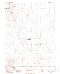
1988 Map of Trappman Hills
USGS Topo · Published 1988About this map
Wilsons Camp serves as a lone human waypoint in this high-desert landscape, situated along the southern boundary of the Nellis Air Force Range. The map reveals a region defined by complex geological prospecting, with numerous prospects and mine shafts dotting the slopes of the Cactus Range and the Trappman Hills. This concentration of extraction points, including the Antelope View Mine, indicates the intense mineral exploration that characterized Nye County's interior during the 20th century.
Find a feature on this map
22 named features on this map. Tap any name to fly to it.
Don’t see what you’re looking for? This feature index may not catch every label — zoom into the map to look around manually.
Map Details
Editions of this 1988 Trappman Hills Map
This is the sole edition of this map. No revisions or reprints were ever made.
Other maps of this area

1908 · Kawich
USGS Topo · 1:250,000

1942 · Tolicha Peak
USGS Topo · 1:125,000

1942 · Cactus Range
USGS Topo · 1:125,000

1952 · Mellan
USGS Topo · 1:62,500

1952 · Cactus Spring
USGS Topo · 1:62,500
1952 · Black Mtn
USGS Topo · 1:62,500

1954 · Goldfield
USGS Topo · 1:250,000

1955 · Goldfield
USGS Topo · 1:250,000

1958 · Goldfield
USGS Topo · 1:250,000

1962 · Goldfield
USGS Topo · 1:250,000