
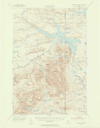
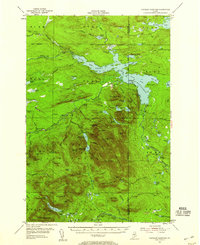
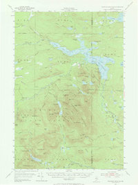
1955 Map of Traveler Mountain
USGS Topo · Published 1987About this map
Baxter State Park and its dominant geological elevations define this portion of the Maine north woods during the mid-1950s. The landscape is anchored by the massive Traveler Mountain range, featuring The Traveler and North Traveler Mtn, whose ridges rise sharply above the East Branch Penobscot River. Water dominates the eastern and northern portions of the quadrangle, notably at Grand Lake Matagamon, where Louse Island and Hub Hall Cove mark the shoreline. Human presence is sparse, represented by isolated outposts like Trout Brook Farm and Black Brook Farm. The transportation network consists primarily of rough paths such as the Freezeout Road and a Tote Road, reflecting the area's history of logging and early conservation. Significant river features like Grand Pitch on the Penobscot illustrate the treacherous nature of these waterways before modern management.
Find a feature on this map
118 named features on this map. Tap any name to fly to it.
Don’t see what you’re looking for? This feature index may not catch every label — zoom into the map to look around manually.
Map Details
Editions of this 1955 Traveler Mountain Map
4 editions found
Historical Maps of Nesourdnahunk Township Through Time
599 maps found

1920 Moosehead Lake
Piscataquis County, ME

1922 Moosehead Lake
Piscataquis County, ME

1927 Katahdin
Piscataquis County, ME

1930 Katahdin
Piscataquis County, ME

1930 Moosehead Lake
Piscataquis County, ME

1932 Dover-Foxcroft
Piscataquis County, ME

1933 Guilford
Piscataquis County, ME

1935 Dover-Foxcroft
Piscataquis County, ME

1937 Guilford
Piscataquis County, ME

1940 Sebec
Piscataquis County, ME

1943 Sebec
Piscataquis County, ME

1944 Moosehead Lake
Piscataquis County, ME

1947 Schoodic
Piscataquis County, ME

1948 Kingsbury
Piscataquis County, ME

1949 Katahdin
Piscataquis County, ME

1949 Schoodic
Piscataquis County, ME

1950 Kingsbury
Piscataquis County, ME

1950 Sebec Lake
Piscataquis County, ME

1951 Greenville
Piscataquis County, ME

1952 First Roach Pond
Piscataquis County, ME

1952 Jo-Mary Mountain
Piscataquis County, ME

1953 Telos Lake
Piscataquis County, ME

1954 Allagash Lake
Piscataquis County, ME

1954 Caucomgomoc Lake
Piscataquis County, ME

1954 Chesuncook
Piscataquis County, ME

1954 Churchill Lake
Piscataquis County, ME

1954 Harrington Lake
Piscataquis County, ME

1954 Millinocket Lake
Piscataquis County, ME

1954 North East Carry
Piscataquis County, ME

1954 Ragged Lake
Piscataquis County, ME

1954 Spider Lake
Piscataquis County, ME
1955 Traveler Mountain
Piscataquis County, ME

1957 Moosehead Lake
Piscataquis County, ME

1957 Telos Lake
Piscataquis County, ME

1958 Caucomgomoc Lake
Piscataquis County, ME

1958 Chesuncook
Piscataquis County, ME

1961 Allagash Lake
Piscataquis County, ME

1961 Spider Lake
Piscataquis County, ME

1962 Churchill Lake
Piscataquis County, ME

1975 Dover-Foxcroft NE
Piscataquis County, ME

1975 Dover-Foxcroft NW
Piscataquis County, ME

1975 Guilford NE
Piscataquis County, ME

1975 Guilford NW
Piscataquis County, ME

1975 Guilford SW
Piscataquis County, ME

1975 Kingsbury NE
Piscataquis County, ME

1975 Kingsbury SE
Piscataquis County, ME

1975 Millinocket Lake NW
Piscataquis County, ME

1975 Millinocket Lake SW
Piscataquis County, ME

1975 Mooseleuk Lake SW
Piscataquis County, ME

1975 Traveler Mountain NW
Piscataquis County, ME

1975 Traveler Mountain SW
Piscataquis County, ME

1977 Bald Mountain Pond
Piscataquis County, ME

1977 Barren Mountain West
Piscataquis County, ME

1977 Big Spencer Mountain
Piscataquis County, ME

1977 Big Squaw Pond
Piscataquis County, ME

1977 Greenville
Piscataquis County, ME

1977 Kokadjo
Piscataquis County, ME

1977 Lily Bay
Piscataquis County, ME

1977 Lobster Mountain
Piscataquis County, ME

1977 Monson East
Piscataquis County, ME

1977 Monson West
Piscataquis County, ME

1977 Moosehead
Piscataquis County, ME

1977 Mount Kineo
Piscataquis County, ME

1977 North East Carry
Piscataquis County, ME

1977 Number Four Mountain
Piscataquis County, ME

1977 Penobscot Farm
Piscataquis County, ME

1977 Pine Stream Flowage
Piscataquis County, ME

1977 Spencer Bay
Piscataquis County, ME

1978 Abol Pond
Piscataquis County, ME

1978 Barren Mountain East
Piscataquis County, ME

1978 Big Shanty Mountain
Piscataquis County, ME

1978 Caribou Lake North
Piscataquis County, ME

1978 Caribou Lake South
Piscataquis County, ME

1978 Doubletop Mountain
Piscataquis County, ME

1978 Ebeemee Mountain
Piscataquis County, ME

1978 Farrar Mountain
Piscataquis County, ME

1978 Hardy Pond
Piscataquis County, ME

1978 Harrington Lake
Piscataquis County, ME

1978 Hay Mountain
Piscataquis County, ME

1978 Jo-Mary Mountain
Piscataquis County, ME

1978 Milo North
Piscataquis County, ME

1978 Milo South
Piscataquis County, ME

1978 Mount Katahdin
Piscataquis County, ME

1978 Nahamakanta Stream
Piscataquis County, ME

1978 Pemadumcook Lake
Piscataquis County, ME

1978 Rainbow Lake East
Piscataquis County, ME

1978 Rainbow Lake West
Piscataquis County, ME

1978 Sebec Lake East
Piscataquis County, ME

1978 Sebec Lake West
Piscataquis County, ME

1978 Seboeis Lake
Piscataquis County, ME

1978 Silver Lake
Piscataquis County, ME

1978 Wadleigh Mountain
Piscataquis County, ME

1983 Dover-Foxcroft
Piscataquis County, ME

1983 Milo South
Piscataquis County, ME

1983 South Sebec
Piscataquis County, ME

1984 Cambridge
Piscataquis County, ME

1984 Guilford
Piscataquis County, ME

1984 Sangerville
Piscataquis County, ME

1985 Millinocket Lake West
Piscataquis County, ME

1985 Moosehead Lake
Piscataquis County, ME

1985 Mooseleuk Lake
Piscataquis County, ME

1985 Mooseleuk Mtn
Piscataquis County, ME

1986 Chamberlain Lake
Piscataquis County, ME

1986 Clayton Lake
Piscataquis County, ME

1986 Dover-Foxcroft
Piscataquis County, ME

1986 Fifth Musquacook Lake
Piscataquis County, ME

1986 Fool Brook
Piscataquis County, ME

1986 Third Musquacook Lake
Piscataquis County, ME

1986 Umsaskis Lake East
Piscataquis County, ME

1986 Umsaskis Lake West
Piscataquis County, ME

1988 Abol Pond
Piscataquis County, ME

1988 Barren Mountain East
Piscataquis County, ME

1988 Barren Mountain West
Piscataquis County, ME

1988 Big Shanty Mountain
Piscataquis County, ME

1988 Big Spencer Mtn
Piscataquis County, ME

1988 Caribou Lake North
Piscataquis County, ME

1988 Caribou Lake South
Piscataquis County, ME

1988 Chesuncook
Piscataquis County, ME

1988 Cuxabexis Lake
Piscataquis County, ME

1988 Doubletop Mountain
Piscataquis County, ME

1988 Ebeemee Mountain
Piscataquis County, ME

1988 Farrar Mountain
Piscataquis County, ME

1988 Frost Pond
Piscataquis County, ME

1988 Hardy Pond
Piscataquis County, ME

1988 Harrington Lake
Piscataquis County, ME

1988 Hay Mountain
Piscataquis County, ME

1988 Jo-Mary Mountain
Piscataquis County, ME

1988 Kokadjo
Piscataquis County, ME

1988 Longley Pond
Piscataquis County, ME

1988 Milo North
Piscataquis County, ME

1988 Monson East
Piscataquis County, ME

1988 Mount Katahdin
Piscataquis County, ME

1988 Mud Pond
Piscataquis County, ME

1988 Nahmakanta Stream
Piscataquis County, ME

1988 Nesowadnehunk Lake
Piscataquis County, ME

1988 Number Four Mtn.
Piscataquis County, ME

1988 Pemadumcook Lake
Piscataquis County, ME

1988 Pine Stream Flowage
Piscataquis County, ME

1988 Rainbow Lake East
Piscataquis County, ME

1988 Rainbow Lake West
Piscataquis County, ME

1988 Sebec Lake East
Piscataquis County, ME

1988 Sebec Lake West
Piscataquis County, ME

1988 Seboeis Lake
Piscataquis County, ME

1988 Silver Lake
Piscataquis County, ME

1988 Telos Brook
Piscataquis County, ME

1988 Telos Lake
Piscataquis County, ME

1988 Wadleigh Mountain
Piscataquis County, ME

1988 Wassataquoik Lake
Piscataquis County, ME

1988 Webster Lake
Piscataquis County, ME

1989 Allagash Lake
Piscataquis County, ME

1989 Allagash Pond
Piscataquis County, ME

1989 Bald Mtn Pond
Piscataquis County, ME

1989 Bean Pot Pond
Piscataquis County, ME

1989 Beetle Mountain
Piscataquis County, ME

1989 Big Squaw Pond
Piscataquis County, ME

1989 Caucomgomoc Lake East
Piscataquis County, ME

1989 Caucomgomoc Lake West
Piscataquis County, ME

1989 Chase Lake
Piscataquis County, ME

1989 Churchill Lake
Piscataquis County, ME

1989 Clarkson Pond
Piscataquis County, ME

1989 Greenville
Piscataquis County, ME

1989 Haymock Lake
Piscataquis County, ME

1989 Lily Bay
Piscataquis County, ME

1989 Lobster Mountain
Piscataquis County, ME

1989 Monson West
Piscataquis County, ME

1989 Moosehead
Piscataquis County, ME

1989 Mount Kineo
Piscataquis County, ME

1989 North East Carry
Piscataquis County, ME

1989 Penobscot Farm
Piscataquis County, ME

1989 Ragmuff Stream
Piscataquis County, ME

1989 Soper Mountain
Piscataquis County, ME

1989 Spencer Bay
Piscataquis County, ME

1989 Spider Lake
Piscataquis County, ME

1989 Tramway
Piscataquis County, ME

1989 Upper Russell Pond
Piscataquis County, ME

1989 Wadleigh Pond
Piscataquis County, ME

1989 Wellington
Piscataquis County, ME

1989 Whetstone Pond
Piscataquis County, ME

1994 Chamberlain Lake
Piscataquis County, ME

1994 Dover-Foxcroft
Piscataquis County, ME

1994 Moosehead Lake
Piscataquis County, ME

1997 Mount Katahdin
Piscataquis County, ME

2011 Abol Pond
Piscataquis County, ME

2011 Allagash Lake
Piscataquis County, ME

2011 Allagash Pond
Piscataquis County, ME

2011 Bald Mountain Pond
Piscataquis County, ME

2011 Barren Mountain East
Piscataquis County, ME

2011 Barren Mountain West
Piscataquis County, ME

2011 Bean Pot Pond
Piscataquis County, ME

2011 Beetle Mountain
Piscataquis County, ME

2011 Big Moose Pond
Piscataquis County, ME

2011 Big Shanty Mountain
Piscataquis County, ME

2011 Big Spencer Mountain
Piscataquis County, ME

2011 Cambridge
Piscataquis County, ME

2011 Caribou Lake North
Piscataquis County, ME

2011 Caribou Lake South
Piscataquis County, ME

2011 Caucomgomoc Lake East
Piscataquis County, ME

2011 Caucomgomoc Lake West
Piscataquis County, ME

2011 Chase Lake
Piscataquis County, ME

2011 Chesuncook
Piscataquis County, ME

2011 Churchill Lake
Piscataquis County, ME

2011 Clarkson Pond
Piscataquis County, ME

2011 Clayton Lake
Piscataquis County, ME

2011 Cuxabexis Lake
Piscataquis County, ME

2011 Doubletop Mountain
Piscataquis County, ME

2011 Dover-Foxcroft
Piscataquis County, ME

2011 Ebeemee Mountain
Piscataquis County, ME

2011 Farrar Mountain
Piscataquis County, ME

2011 Fifth Musquacook Lake
Piscataquis County, ME

2011 Fool Brook
Piscataquis County, ME

2011 Frost Pond
Piscataquis County, ME

2011 Greenville
Piscataquis County, ME

2011 Guilford
Piscataquis County, ME

2011 Hardy Pond
Piscataquis County, ME

2011 Harrington Lake
Piscataquis County, ME

2011 Haymock Lake
Piscataquis County, ME

2011 Hay Mountain
Piscataquis County, ME

2011 Jo-Mary Mountain
Piscataquis County, ME

2011 Kokadjo
Piscataquis County, ME

2011 Lily Bay
Piscataquis County, ME

2011 Lobster Mountain
Piscataquis County, ME

2011 Longley Pond
Piscataquis County, ME

2011 Millinocket Lake West
Piscataquis County, ME

2011 Milo North
Piscataquis County, ME

2011 Milo South
Piscataquis County, ME

2011 Monson East
Piscataquis County, ME

2011 Monson West
Piscataquis County, ME

2011 Moosehead
Piscataquis County, ME

2011 Mooseleuk Lake
Piscataquis County, ME

2011 Mooseleuk Mountain
Piscataquis County, ME

2011 Mount Katahdin
Piscataquis County, ME

2011 Mount Kineo
Piscataquis County, ME

2011 Mud Pond
Piscataquis County, ME

2011 Nahmakanta Stream
Piscataquis County, ME

2011 Nesowadnehunk Lake
Piscataquis County, ME

2011 North East Carry
Piscataquis County, ME

2011 Number Four Mountain
Piscataquis County, ME

2011 Pemadumcook Lake
Piscataquis County, ME

2011 Penobscot Farm
Piscataquis County, ME

2011 Pine Stream Flowage
Piscataquis County, ME

2011 Ragmuff Stream
Piscataquis County, ME

2011 Rainbow Lake East
Piscataquis County, ME

2011 Rainbow Lake West
Piscataquis County, ME

2011 Sangerville
Piscataquis County, ME

2011 Sebec Lake East
Piscataquis County, ME

2011 Sebec Lake West
Piscataquis County, ME

2011 Seboeis Lake
Piscataquis County, ME

2011 Silver Lake
Piscataquis County, ME

2011 Soper Mountain
Piscataquis County, ME

2011 South Sebec
Piscataquis County, ME

2011 Spencer Bay
Piscataquis County, ME

2011 Spider Lake
Piscataquis County, ME

2011 Telos Brook
Piscataquis County, ME

2011 Telos Lake
Piscataquis County, ME

2011 Third Musquacook Lake
Piscataquis County, ME

2011 Tramway
Piscataquis County, ME

2011 Umsaskis Lake East
Piscataquis County, ME

2011 Umsaskis Lake West
Piscataquis County, ME

2011 Upper Russell Pond
Piscataquis County, ME

2011 Wadleigh Mountain
Piscataquis County, ME

2011 Wadleigh Pond
Piscataquis County, ME

2011 Wassataquoik Lake
Piscataquis County, ME

2011 Webster Lake
Piscataquis County, ME

2011 Wellington
Piscataquis County, ME

2011 Whetstone Pond
Piscataquis County, ME

2014 Abol Pond
Piscataquis County, ME

2014 Allagash Lake
Piscataquis County, ME

2014 Allagash Pond
Piscataquis County, ME

2014 Bald Mountain Pond
Piscataquis County, ME

2014 Barren Mountain East
Piscataquis County, ME

2014 Barren Mountain West
Piscataquis County, ME

2014 Bean Pot Pond
Piscataquis County, ME

2014 Beetle Mountain
Piscataquis County, ME

2014 Big Moose Pond
Piscataquis County, ME

2014 Big Shanty Mountain
Piscataquis County, ME

2014 Big Spencer Mountain
Piscataquis County, ME

2014 Cambridge
Piscataquis County, ME

2014 Caribou Lake North
Piscataquis County, ME

2014 Caribou Lake South
Piscataquis County, ME

2014 Caucomgomoc Lake East
Piscataquis County, ME

2014 Caucomgomoc Lake West
Piscataquis County, ME

2014 Chase Lake
Piscataquis County, ME

2014 Chesuncook
Piscataquis County, ME

2014 Churchill Lake
Piscataquis County, ME

2014 Clarkson Pond
Piscataquis County, ME

2014 Clayton Lake
Piscataquis County, ME

2014 Cuxabexis Lake
Piscataquis County, ME

2014 Doubletop Mountain
Piscataquis County, ME

2014 Dover-Foxcroft
Piscataquis County, ME

2014 Ebeemee Mountain
Piscataquis County, ME

2014 Farrar Mountain
Piscataquis County, ME

2014 Fifth Musquacook Lake
Piscataquis County, ME

2014 Fool Brook
Piscataquis County, ME

2014 Frost Pond
Piscataquis County, ME

2014 Greenville
Piscataquis County, ME

2014 Guilford
Piscataquis County, ME

2014 Hardy Pond
Piscataquis County, ME

2014 Harrington Lake
Piscataquis County, ME

2014 Haymock Lake
Piscataquis County, ME

2014 Hay Mountain
Piscataquis County, ME

2014 Jo-Mary Mountain
Piscataquis County, ME

2014 Kokadjo
Piscataquis County, ME

2014 Lily Bay
Piscataquis County, ME

2014 Lobster Mountain
Piscataquis County, ME

2014 Longley Pond
Piscataquis County, ME

2014 Millinocket Lake West
Piscataquis County, ME

2014 Milo North
Piscataquis County, ME

2014 Milo South
Piscataquis County, ME

2014 Monson East
Piscataquis County, ME

2014 Monson West
Piscataquis County, ME

2014 Moosehead
Piscataquis County, ME

2014 Mooseleuk Lake
Piscataquis County, ME

2014 Mooseleuk Mountain
Piscataquis County, ME

2014 Mount Katahdin
Piscataquis County, ME

2014 Mount Kineo
Piscataquis County, ME

2014 Mud Pond
Piscataquis County, ME

2014 Nahmakanta Stream
Piscataquis County, ME

2014 Nesowadnehunk Lake
Piscataquis County, ME

2014 North East Carry
Piscataquis County, ME

2014 Number Four Mountain
Piscataquis County, ME

2014 Pemadumcook Lake
Piscataquis County, ME

2014 Penobscot Farm
Piscataquis County, ME

2014 Pine Stream Flowage
Piscataquis County, ME

2014 Ragmuff Stream
Piscataquis County, ME

2014 Rainbow Lake East
Piscataquis County, ME

2014 Rainbow Lake West
Piscataquis County, ME

2014 Sangerville
Piscataquis County, ME

2014 Sebec Lake East
Piscataquis County, ME

2014 Sebec Lake West
Piscataquis County, ME

2014 Seboeis Lake
Piscataquis County, ME

2014 Silver Lake
Piscataquis County, ME

2014 Soper Mountain
Piscataquis County, ME

2014 South Sebec
Piscataquis County, ME

2014 Spencer Bay
Piscataquis County, ME

2014 Spider Lake
Piscataquis County, ME

2014 Telos Brook
Piscataquis County, ME

2014 Telos Lake
Piscataquis County, ME

2014 Third Musquacook Lake
Piscataquis County, ME

2014 Tramway
Piscataquis County, ME

2014 Umsaskis Lake East
Piscataquis County, ME

2014 Umsaskis Lake West
Piscataquis County, ME

2014 Upper Russell Pond
Piscataquis County, ME

2014 Wadleigh Mountain
Piscataquis County, ME

2014 Wadleigh Pond
Piscataquis County, ME

2014 Wassataquoik Lake
Piscataquis County, ME

2014 Webster Lake
Piscataquis County, ME

2014 Wellington
Piscataquis County, ME

2014 Whetstone Pond
Piscataquis County, ME

2018 Abol Pond
Piscataquis County, ME

2018 Allagash Lake
Piscataquis County, ME

2018 Allagash Pond
Piscataquis County, ME

2018 Bald Mountain Pond
Piscataquis County, ME

2018 Barren Mountain East
Piscataquis County, ME

2018 Barren Mountain West
Piscataquis County, ME

2018 Bean Pot Pond
Piscataquis County, ME

2018 Beetle Mountain
Piscataquis County, ME

2018 Big Moose Pond
Piscataquis County, ME

2018 Big Shanty Mountain
Piscataquis County, ME

2018 Big Spencer Mountain
Piscataquis County, ME

2018 Cambridge
Piscataquis County, ME

2018 Caribou Lake North
Piscataquis County, ME

2018 Caribou Lake South
Piscataquis County, ME

2018 Caucomgomoc Lake East
Piscataquis County, ME

2018 Caucomgomoc Lake West
Piscataquis County, ME

2018 Chase Lake
Piscataquis County, ME

2018 Chesuncook
Piscataquis County, ME

2018 Churchill Lake
Piscataquis County, ME

2018 Clarkson Pond
Piscataquis County, ME

2018 Clayton Lake
Piscataquis County, ME

2018 Cuxabexis Lake
Piscataquis County, ME

2018 Doubletop Mountain
Piscataquis County, ME

2018 Dover-Foxcroft
Piscataquis County, ME

2018 Ebeemee Mountain
Piscataquis County, ME

2018 Farrar Mountain
Piscataquis County, ME

2018 Fifth Musquacook Lake
Piscataquis County, ME

2018 Fool Brook
Piscataquis County, ME

2018 Frost Pond
Piscataquis County, ME

2018 Greenville
Piscataquis County, ME

2018 Guilford
Piscataquis County, ME

2018 Hardy Pond
Piscataquis County, ME

2018 Harrington Lake
Piscataquis County, ME

2018 Haymock Lake
Piscataquis County, ME

2018 Hay Mountain
Piscataquis County, ME

2018 Jo-Mary Mountain
Piscataquis County, ME

2018 Kokadjo
Piscataquis County, ME

2018 Lily Bay
Piscataquis County, ME

2018 Lobster Mountain
Piscataquis County, ME

2018 Longley Pond
Piscataquis County, ME

2018 Millinocket Lake West
Piscataquis County, ME

2018 Milo North
Piscataquis County, ME

2018 Milo South
Piscataquis County, ME

2018 Monson East
Piscataquis County, ME

2018 Monson West
Piscataquis County, ME

2018 Moosehead
Piscataquis County, ME

2018 Mooseleuk Lake
Piscataquis County, ME

2018 Mooseleuk Mountain
Piscataquis County, ME

2018 Mount Katahdin
Piscataquis County, ME

2018 Mount Kineo
Piscataquis County, ME

2018 Mud Pond
Piscataquis County, ME

2018 Nahmakanta Stream
Piscataquis County, ME

2018 Nesowadnehunk Lake
Piscataquis County, ME

2018 North East Carry
Piscataquis County, ME

2018 Number Four Mountain
Piscataquis County, ME

2018 Pemadumcook Lake
Piscataquis County, ME

2018 Penobscot Farm
Piscataquis County, ME

2018 Pine Stream Flowage
Piscataquis County, ME

2018 Ragmuff Stream
Piscataquis County, ME

2018 Rainbow Lake East
Piscataquis County, ME

2018 Rainbow Lake West
Piscataquis County, ME

2018 Sangerville
Piscataquis County, ME

2018 Sebec Lake East
Piscataquis County, ME

2018 Sebec Lake West
Piscataquis County, ME

2018 Seboeis Lake
Piscataquis County, ME

2018 Silver Lake
Piscataquis County, ME

2018 Soper Mountain
Piscataquis County, ME

2018 South Sebec
Piscataquis County, ME

2018 Spencer Bay
Piscataquis County, ME

2018 Spider Lake
Piscataquis County, ME

2018 Telos Brook
Piscataquis County, ME

2018 Telos Lake
Piscataquis County, ME

2018 Third Musquacook Lake
Piscataquis County, ME

2018 Tramway
Piscataquis County, ME

2018 Umsaskis Lake East
Piscataquis County, ME

2018 Umsaskis Lake West
Piscataquis County, ME

2018 Upper Russell Pond
Piscataquis County, ME

2018 Wadleigh Mountain
Piscataquis County, ME

2018 Wadleigh Pond
Piscataquis County, ME

2018 Wassataquoik Lake
Piscataquis County, ME

2018 Webster Lake
Piscataquis County, ME

2018 Wellington
Piscataquis County, ME

2018 Whetstone Pond
Piscataquis County, ME

2021 Abol Pond
Piscataquis County, ME

2021 Allagash Lake
Piscataquis County, ME

2021 Allagash Pond
Piscataquis County, ME

2021 Bald Mountain Pond
Piscataquis County, ME

2021 Barren Mountain East
Piscataquis County, ME

2021 Barren Mountain West
Piscataquis County, ME

2021 Bean Pot Pond
Piscataquis County, ME

2021 Beetle Mountain
Piscataquis County, ME

2021 Big Moose Pond
Piscataquis County, ME

2021 Big Shanty Mountain
Piscataquis County, ME

2021 Big Spencer Mountain
Piscataquis County, ME

2021 Cambridge
Piscataquis County, ME

2021 Caribou Lake North
Piscataquis County, ME

2021 Caribou Lake South
Piscataquis County, ME

2021 Caucomgomoc Lake East
Piscataquis County, ME

2021 Caucomgomoc Lake West
Piscataquis County, ME

2021 Chase Lake
Piscataquis County, ME

2021 Chesuncook
Piscataquis County, ME

2021 Churchill Lake
Piscataquis County, ME

2021 Clarkson Pond
Piscataquis County, ME

2021 Clayton Lake
Piscataquis County, ME

2021 Cuxabexis Lake
Piscataquis County, ME

2021 Doubletop Mountain
Piscataquis County, ME

2021 Dover-Foxcroft
Piscataquis County, ME

2021 Ebeemee Mountain
Piscataquis County, ME

2021 Farrar Mountain
Piscataquis County, ME

2021 Fifth Musquacook Lake
Piscataquis County, ME

2021 Fool Brook
Piscataquis County, ME

2021 Frost Pond
Piscataquis County, ME

2021 Greenville
Piscataquis County, ME

2021 Guilford
Piscataquis County, ME

2021 Hardy Pond
Piscataquis County, ME

2021 Harrington Lake
Piscataquis County, ME

2021 Haymock Lake
Piscataquis County, ME

2021 Hay Mountain
Piscataquis County, ME

2021 Jo-Mary Mountain
Piscataquis County, ME

2021 Kokadjo
Piscataquis County, ME

2021 Lily Bay
Piscataquis County, ME

2021 Lobster Mountain
Piscataquis County, ME

2021 Longley Pond
Piscataquis County, ME

2021 Millinocket Lake West
Piscataquis County, ME

2021 Milo North
Piscataquis County, ME

2021 Milo South
Piscataquis County, ME

2021 Monson East
Piscataquis County, ME

2021 Monson West
Piscataquis County, ME

2021 Moosehead
Piscataquis County, ME

2021 Mooseleuk Lake
Piscataquis County, ME

2021 Mooseleuk Mountain
Piscataquis County, ME

2021 Mount Katahdin
Piscataquis County, ME

2021 Mount Kineo
Piscataquis County, ME

2021 Mud Pond
Piscataquis County, ME

2021 Nahmakanta Stream
Piscataquis County, ME

2021 Nesowadnehunk Lake
Piscataquis County, ME

2021 North East Carry
Piscataquis County, ME

2021 Number Four Mountain
Piscataquis County, ME

2021 Pemadumcook Lake
Piscataquis County, ME

2021 Penobscot Farm
Piscataquis County, ME

2021 Pine Stream Flowage
Piscataquis County, ME

2021 Ragmuff Stream
Piscataquis County, ME

2021 Rainbow Lake East
Piscataquis County, ME

2021 Rainbow Lake West
Piscataquis County, ME

2021 Sangerville
Piscataquis County, ME

2021 Sebec Lake East
Piscataquis County, ME

2021 Sebec Lake West
Piscataquis County, ME

2021 Seboeis Lake
Piscataquis County, ME

2021 Silver Lake
Piscataquis County, ME

2021 Soper Mountain
Piscataquis County, ME

2021 South Sebec
Piscataquis County, ME

2021 Spencer Bay
Piscataquis County, ME

2021 Spider Lake
Piscataquis County, ME

2021 Telos Brook
Piscataquis County, ME

2021 Telos Lake
Piscataquis County, ME

2021 Third Musquacook Lake
Piscataquis County, ME

2021 Tramway
Piscataquis County, ME

2021 Umsaskis Lake East
Piscataquis County, ME

2021 Umsaskis Lake West
Piscataquis County, ME

2021 Upper Russell Pond
Piscataquis County, ME

2021 Wadleigh Mountain
Piscataquis County, ME

2021 Wadleigh Pond
Piscataquis County, ME

2021 Wassataquoik Lake
Piscataquis County, ME

2021 Webster Lake
Piscataquis County, ME

2021 Wellington
Piscataquis County, ME

2021 Whetstone Pond
Piscataquis County, ME

2023 Big Moose Pond
Piscataquis County, ME

2023 Greenville
Piscataquis County, ME

2024 Abol Pond
Piscataquis County, ME

2024 Allagash Lake
Piscataquis County, ME

2024 Allagash Pond
Piscataquis County, ME

2024 Bald Mountain Pond
Piscataquis County, ME

2024 Barren Mountain East
Piscataquis County, ME

2024 Barren Mountain West
Piscataquis County, ME

2024 Bean Pot Pond
Piscataquis County, ME

2024 Beetle Mountain
Piscataquis County, ME

2024 Big Moose Pond
Piscataquis County, ME

2024 Big Shanty Mountain
Piscataquis County, ME

2024 Big Spencer Mountain
Piscataquis County, ME

2024 Cambridge
Piscataquis County, ME

2024 Caribou Lake North
Piscataquis County, ME

2024 Caribou Lake South
Piscataquis County, ME

2024 Caucomgomoc Lake East
Piscataquis County, ME

2024 Caucomgomoc Lake West
Piscataquis County, ME

2024 Chase Lake
Piscataquis County, ME

2024 Chesuncook
Piscataquis County, ME

2024 Churchill Lake
Piscataquis County, ME

2024 Clarkson Pond
Piscataquis County, ME

2024 Clayton Lake
Piscataquis County, ME

2024 Cuxabexis Lake
Piscataquis County, ME

2024 Doubletop Mountain
Piscataquis County, ME

2024 Dover-Foxcroft
Piscataquis County, ME

2024 Ebeemee Mountain
Piscataquis County, ME

2024 Farrar Mountain
Piscataquis County, ME

2024 Fifth Musquacook Lake
Piscataquis County, ME

2024 Fool Brook
Piscataquis County, ME

2024 Frost Pond
Piscataquis County, ME

2024 Greenville
Piscataquis County, ME

2024 Guilford
Piscataquis County, ME

2024 Hardy Pond
Piscataquis County, ME

2024 Harrington Lake
Piscataquis County, ME

2024 Haymock Lake
Piscataquis County, ME

2024 Hay Mountain
Piscataquis County, ME

2024 Jo-Mary Mountain
Piscataquis County, ME

2024 Kokadjo
Piscataquis County, ME

2024 Lily Bay
Piscataquis County, ME

2024 Lobster Mountain
Piscataquis County, ME

2024 Longley Pond
Piscataquis County, ME

2024 Millinocket Lake West
Piscataquis County, ME

2024 Milo North
Piscataquis County, ME

2024 Milo South
Piscataquis County, ME

2024 Monson East
Piscataquis County, ME

2024 Monson West
Piscataquis County, ME

2024 Moosehead
Piscataquis County, ME

2024 Mooseleuk Lake
Piscataquis County, ME

2024 Mooseleuk Mountain
Piscataquis County, ME

2024 Mount Katahdin
Piscataquis County, ME

2024 Mount Kineo
Piscataquis County, ME

2024 Mud Pond
Piscataquis County, ME

2024 Nahmakanta Stream
Piscataquis County, ME

2024 Nesowadnehunk Lake
Piscataquis County, ME

2024 North East Carry
Piscataquis County, ME

2024 Number Four Mountain
Piscataquis County, ME

2024 Pemadumcook Lake
Piscataquis County, ME

2024 Penobscot Farm
Piscataquis County, ME

2024 Pine Stream Flowage
Piscataquis County, ME

2024 Ragmuff Stream
Piscataquis County, ME

2024 Rainbow Lake East
Piscataquis County, ME

2024 Rainbow Lake West
Piscataquis County, ME

2024 Sangerville
Piscataquis County, ME

2024 Sebec Lake East
Piscataquis County, ME

2024 Sebec Lake West
Piscataquis County, ME

2024 Seboeis Lake
Piscataquis County, ME

2024 Silver Lake
Piscataquis County, ME

2024 Soper Mountain
Piscataquis County, ME

2024 South Sebec
Piscataquis County, ME

2024 Spencer Bay
Piscataquis County, ME

2024 Spider Lake
Piscataquis County, ME

2024 Telos Brook
Piscataquis County, ME

2024 Telos Lake
Piscataquis County, ME

2024 Third Musquacook Lake
Piscataquis County, ME

2024 Tramway
Piscataquis County, ME

2024 Umsaskis Lake East
Piscataquis County, ME

2024 Umsaskis Lake West
Piscataquis County, ME

2024 Upper Russell Pond
Piscataquis County, ME

2024 Wadleigh Mountain
Piscataquis County, ME

2024 Wadleigh Pond
Piscataquis County, ME

2024 Wassataquoik Lake
Piscataquis County, ME

2024 Webster Lake
Piscataquis County, ME

2024 Wellington
Piscataquis County, ME

2024 Whetstone Pond
Piscataquis County, ME