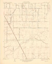
1927 Map of Traver
USGS Topo · Published 1927About this map
The Southern Pacific railroad cuts a straight diagonal through this Central Valley landscape, defining the layout of Traver and the surrounding agricultural grid. Surveyed in the mid-1920s, the terrain is defined by a complex network of irrigation and water management, where the Kings River and St Johns River feed into numerous smaller channels like Cottonwood Creek and the Settlers Ditch. This era shows a rural landscape transitioning from open range to a highly organized patchwork of family-named avenues and school districts.
Find a feature on this map
46 named features on this map. Tap any name to fly to it.
Don’t see what you’re looking for? This feature index may not catch every label — zoom into the map to look around manually.
Map Details
Editions of this 1927 Traver Map
2 editions found
Other maps of this area

1922 · Trimmer
USGS Topo · 1:96,000

1923 · Sultana
USGS Topo · 1:31,680

1924 · Reedley
USGS Topo · 1:31,680

1924 · Selma
USGS Topo · 1:31,680

1924 · Dinuba
USGS Topo · 1:125,000

1926 · Goshen
USGS Topo · 1:31,680

1926 · Burris Park
USGS Topo · 1:31,680

1927 · Traver
USGS Topo · 1:31,680

1927 · Monson
USGS Topo · 1:31,680

1927 · Remnoy
USGS Topo · 1:31,680