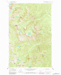
1963 Map of Treasure Mountain
USGS Topo · Published 1984About this map
The Cabinet Mountains dominate this high-elevation landscape, where the Kootenai National Forest and Kaniksu National Forest meet. The 1963 survey, updated with 1982 aerial revisions, reveals a terrain defined by steep ridges and glacial basins, including the distinctive Hanging Valley and numerous alpine lakes such as Lake Osakis, Vimy Lake, and Klatawa Lake. The presence of several Mines and Prospects near the Wilderness Boundary indicates the era's mining activity in the vicinity of Treasure Mountain and Mount Snowy.
Find a feature on this map
47 named features on this map. Tap any name to fly to it.
Don’t see what you’re looking for? This feature index may not catch every label — zoom into the map to look around manually.
Map Details
Editions of this 1963 Treasure Mountain Map
2 editions found
Other maps of this area

1920 · Libby
USGS Topo · 1:125,000

1930 · Libby
USGS Topo · 1:125,000

1932 · Libby
USGS Topo · 1:125,000

1957 · Kalispell
USGS Topo · 1:250,000

1960 · Kalispell
USGS Topo · 1:250,000

1961 · Kalispell
USGS Topo · 1:250,000

1963 · Scenery Mountain
USGS Topo · 1:24,000

1963 · Treasure Mountain
USGS Topo · 1:24,000
1963 · Crowell Mountain
USGS Topo · 1:24,000
1963 · Kootenai Falls
USGS Topo · 1:24,000