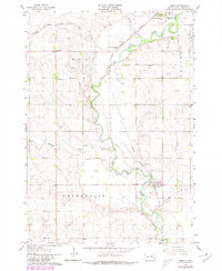
1963 Map of Trent
USGS Topo · Published 1980About this map
The Big Sioux River snakes through the heart of this landscape, its winding course defining the agricultural character of eastern South Dakota. In the early 1960s, the rail infrastructure remains a dominant feature, with the Chicago Milwaukee St Paul and Pacific line connecting the settlements of Egan and Trent. The junction near Sioux Falls Junction highlights the importance of these transport corridors to the regional grain and gravel industries, evidenced by numerous Gravel Pits distributed along the river valley.
Find a feature on this map
18 named features on this map. Tap any name to fly to it.
Don’t see what you’re looking for? This feature index may not catch every label — zoom into the map to look around manually.
Map Details
Editions of this 1963 Trent Map
2 editions found
Other maps of this area

1953 · Watertown
USGS Topo · 1:250,000

1955 · Sioux Falls
USGS Topo · 1:250,000

1958 · Sioux Falls
USGS Topo · 1:250,000

1958 · Watertown
USGS Topo · 1:250,000

1962 · Colton SE
USGS Topo · 1:24,000

1962 · Dell Rapids
USGS Topo · 1:24,000

1963 · Trent
USGS Topo · 1:24,000

1963 · Colman
USGS Topo · 1:24,000

1964 · Rutland SE
USGS Topo · 1:24,000

1964 · Flandreau SW
USGS Topo · 1:24,000