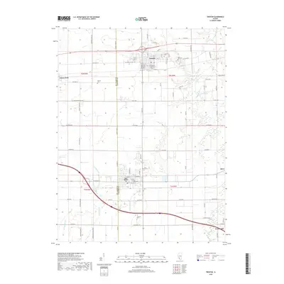
2018 Map of Trenton
USGS Topo · Published 2018About this map
New Baden and Trenton serve as the primary hubs in this Illinois landscape, which straddles the boundary between St. Clair Co and Clinton Co. The settlement pattern follows a clear grid of section lines and rural routes like Clinton Co Line Rd and Old US Hwy 50, connecting smaller communities like Summerfield, Albers, and Damiansville. Local history is preserved in numerous burial sites including Saint Marys Cem, Wittmer Cem, and Green Mount Cem. The terrain is defined by low-lying drainage features such as Rayhill Slough, Reinhardt Slough, and the meandering Sugar Cr. The presence of Coal Mine Rd near Summerfield hints at the area's industrial past, while water features like Queens Lake Br and Rocky Ford Pond punctuate the agricultural fields that dominate the territory between these established towns.
Find a feature on this map
91 named features on this map. Tap any name to fly to it.
Don’t see what you’re looking for? This feature index may not catch every label — zoom into the map to look around manually.
Map Details
Editions of this 2018 Trenton Map
This is the sole edition of this map. No revisions or reprints were ever made.
Other maps of this area

1906 · Breese
USGS Topo · 1:62,500

1907 · Breese
USGS Topo · 1:62,500

1907 · Belleville
USGS Topo · 1:62,500

1910 · Okawville
USGS Topo · 1:62,500

1912 · New Athens
USGS Topo · 1:62,500

1935 · Lebanon
USGS Topo · 1:24,000

1940 · Okawville
USGS Topo · 1:62,500

1949 · Lebanon
USGS Topo · 1:24,000

1949 · St. Jacob
USGS Topo · 1:24,000
1954 · Lebanon
USGS Topo · 1:24,000