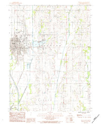
1984 Map of Trenton East
USGS Topo · Published 1984About this map
Trenton serves as the focal point of this Grundy County landscape, shown here during its mid-1980s development. The city’s eastern edge transitions from a dense street grid into a region defined by managed water and infrastructure, including a local Airport and a Radio Tower. The geography is shaped by the confluence of major waterways, where the Thompson River and Muddy Creek meet to the south. Central to the area’s recreation and water management is Trenton Lake, situated just east of the primary settlement. The survey detail reflects a late-20th-century rural-to-urban interface, documenting essential utilities like the Sewage Disp Ponds and a local Cem, providing a clear record of the civic and natural boundaries within Trenton, Lincoln, and Jackson townships.
Find a feature on this map
16 named features on this map. Tap any name to fly to it.
Don’t see what you’re looking for? This feature index may not catch every label — zoom into the map to look around manually.
Map Details
Editions of this 1984 Trenton East Map
This is the sole edition of this map. No revisions or reprints were ever made.
Other maps of this area

1921 · Chillicothe
USGS Topo · 1:62,500

1923 · Chillicothe
USGS Topo · 1:62,500

1924 · Chula
USGS Topo · 1:62,500

1946 · Galt
USGS Topo · 1:62,500

1947 · Chula
USGS Topo · 1:62,500

1948 · Trenton
USGS Topo · 1:62,500

1949 · Galt
USGS Topo · 1:62,500

1953 · Moberly
USGS Topo · 1:250,000

1954 · Centerville
USGS Topo · 1:250,000

1954 · Moberly
USGS Topo · 1:250,000