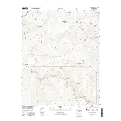
2013 Map of Tres Ritos
USGS Topo · Published 2013About this map
Carson National Forest spans this high-elevation landscape where the Sangre de Cristo Mountains meet the Santa Fe Mountains. The 2013 survey reveals a region defined by recreational development and traditional New Mexican settlements, centered primarily along the route of State Highway 518. Tiny communities like Las Mochas and Tres Ritos sit nestled in the deep river valleys, while the Sipapu Ski Area and various Forest Service sites like Agua Piedra Campground and Comales Campground mark the area's modern role as a destination for outdoor enthusiasts.
Find a feature on this map
62 named features on this map. Tap any name to fly to it.
Don’t see what you’re looking for? This feature index may not catch every label — zoom into the map to look around manually.
Map Details
Editions of this 2013 Tres Ritos Map
This is the sole edition of this map. No revisions or reprints were ever made.
Other maps of this area

1954 · Raton
USGS Topo · 1:250,000

1958 · Raton
USGS Topo · 1:250,000

1964 · Tres Ritos
USGS Topo · 1:24,000

1964 · Ranchos De Taos
USGS Topo · 1:24,000

1964 · Penasco
USGS Topo · 1:24,000

1964 · Taos SW
USGS Topo · 1:24,000
1964 · Jicarita Peak
USGS Topo · 1:24,000
1964 · El Valle
USGS Topo · 1:24,000

1965 · Holman
USGS Topo · 1:24,000

1965 · Shady Brook
USGS Topo · 1:24,000