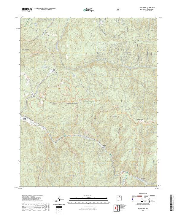
2023 Map of Tres Ritos
USGS Topo · Published 2023About this map
Tres Ritos and Sipapu sit along the winding course of the Rio Pueblo in this contemporary study of Taos County’s high country. This landscape is a complex intersection of the Carson National Forest, Sangre de Cristo Mountains, and Santa Fe Mountains. The map documents a dense network of high-elevation trails, including the Ojito-Maes Trl and the Amole Trl, which connect deep drainages like Osha Canyon and Flechado Canyon. The presence of small settlements like Las Mochas and Rock Wall near major water sources like the Rio Grande del Rancho illustrates the continued importance of river valleys for habitation in this mountainous terrain. From the heights of Gallegos Peak to the various springs like Apache Springs and Maestas Spring, the map provides an essential view of the watershed and recreational geography of the region.
Find a feature on this map
58 named features on this map. Tap any name to fly to it.
Don’t see what you’re looking for? This feature index may not catch every label — zoom into the map to look around manually.
Map Details
Editions of this 2023 Tres Ritos Map
This is the sole edition of this map. No revisions or reprints were ever made.
Other maps of this area

1954 · Raton
USGS Topo · 1:250,000

1958 · Raton
USGS Topo · 1:250,000

1964 · Tres Ritos
USGS Topo · 1:24,000

1964 · Ranchos De Taos
USGS Topo · 1:24,000

1964 · Penasco
USGS Topo · 1:24,000

1964 · Taos SW
USGS Topo · 1:24,000
1964 · Jicarita Peak
USGS Topo · 1:24,000
1964 · El Valle
USGS Topo · 1:24,000

1965 · Holman
USGS Topo · 1:24,000

1965 · Shady Brook
USGS Topo · 1:24,000