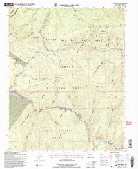
1995 Map of Tres Ritos
USGS Topo · Published 1997About this map
Rancho del Rio Grande Grant and the Santa Barbara Grant define the complex land tenure of this high mountain region where the Sangre de Cristo Mountains meet the Picuris Mountains. The settlement pattern follows the narrow valley of the Rio Pueblo, where small communities like Las Mochas and Tres Ritos are located along the canyon floors. This 1990s revision shows a landscape balanced between traditional grazing grounds and modern recreation, evidenced by the Sipapu Ski Area and various Forest Service facilities like Llanito Frio and Flechado. The presence of the Cristobal de la Serna Grant in the northwest further illustrates the area's deep history of Spanish and Mexican land grants. In the high backcountry, numerous peaks and named canyons like Osha Canyon and Amole Canyon dominate the topography of the Carson National Forest.
Find a feature on this map
53 named features on this map. Tap any name to fly to it.
Don’t see what you’re looking for? This feature index may not catch every label — zoom into the map to look around manually.
Map Details
Editions of this 1995 Tres Ritos Map
This is the sole edition of this map. No revisions or reprints were ever made.
Other maps of this area

1954 · Raton
USGS Topo · 1:250,000

1958 · Raton
USGS Topo · 1:250,000

1964 · Tres Ritos
USGS Topo · 1:24,000

1964 · Ranchos De Taos
USGS Topo · 1:24,000

1964 · Penasco
USGS Topo · 1:24,000

1964 · Taos SW
USGS Topo · 1:24,000
1964 · Jicarita Peak
USGS Topo · 1:24,000
1964 · El Valle
USGS Topo · 1:24,000

1965 · Holman
USGS Topo · 1:24,000

1965 · Shady Brook
USGS Topo · 1:24,000