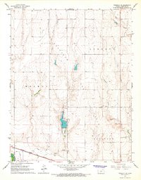
1966 Map of Tribune 3 SE
USGS Topo · Published 1967About this map
Hamilton County State Lake sits at the center of this 1960s landscape, providing a primary water feature amidst the high plains terrain of western Kansas. The map captures the infrastructure of the High Plains, where the Atchison Topeka and Santa Fe railroad corridor runs parallel to the Arkansas River and the Alamo Ditch. This transportation and irrigation network at the southern edge of the sheet contrasts with the open spaces of the Syracuse Field and the rural reaches of Medway and Liberty. North of the river, several drainage systems including Bradshaw Creek, Plum Creek, and Sand Creek cut through the topography. Local social and industrial landmarks are present in the form of the Syracuse Country Club and various Gravel Pits, showing the intersection of recreation and resource extraction during this era.
Find a feature on this map
13 named features on this map. Tap any name to fly to it.
Don’t see what you’re looking for? This feature index may not catch every label — zoom into the map to look around manually.
Map Details
Editions of this 1966 Tribune 3 SE Map
2 editions found
Other maps of this area

1900 · Syracuse
USGS Topo · 1:125,000

1920 · Syracuse
USGS Topo · 1:125,000

1955 · Dodge City
USGS Topo · 1:250,000

1955 · Scott City
USGS Topo · 1:250,000

1958 · Dodge City
USGS Topo · 1:250,000

1958 · Scott City
USGS Topo · 1:250,000

1959 · Dodge City
USGS Topo · 1:250,000
1966 · Tribune 3 SW
USGS Topo · 1:24,000

1966 · Syracuse East
USGS Topo · 1:24,000
1966 · Syracuse West
USGS Topo · 1:24,000