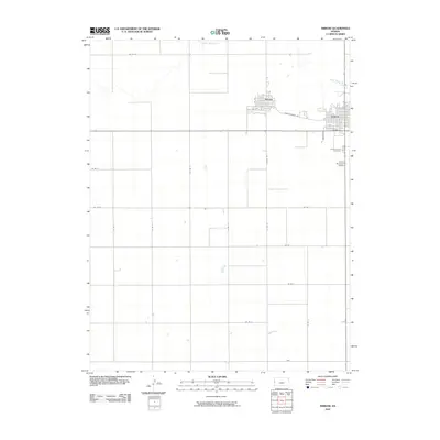
2010 Map of Tribune
USGS Topo · Published 2010About this map
Tribune and neighboring Horace form the primary hubs of activity in this high plains landscape of western Kansas. The layout reveals the tight grid of the county seat, where residential streets like New York Ave and Kansas St converge near the Horace-Tribune Rd, which serves as a vital corridor between the two settlements. To the north, the winding course of White Woman Creek cuts a path through the section lines, providing a rare natural break in the orderly surveying of the agricultural fields.
Find a feature on this map
25 named features on this map. Tap any name to fly to it.
Don’t see what you’re looking for? This feature index may not catch every label — zoom into the map to look around manually.
Map Details
Editions of this 2010 Tribune Map
This is the sole edition of this map. No revisions or reprints were ever made.
Other maps of this area

1955 · Scott City
USGS Topo · 1:250,000

1958 · Scott City
USGS Topo · 1:250,000

1970 · Selkirk SW
USGS Topo · 1:24,000

1970 · Sharon Springs 3 SE
USGS Topo · 1:24,000

1970 · Sharon Springs 4 SW
USGS Topo · 1:24,000
1970 · Sharon Springs 3 SW
USGS Topo · 1:24,000

1970 · Selkirk NW
USGS Topo · 1:24,000
1970 · Tribune NW
USGS Topo · 1:24,000

1970 · Tribune SE
USGS Topo · 1:24,000
1970 · Tribune SW
USGS Topo · 1:24,000