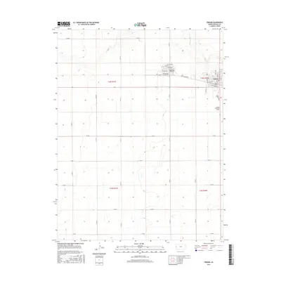
2015 Map of Tribune
USGS Topo · Published 2015About this map
Tribune and Horace serve as the primary population centers in this section of the High Plains, connected by the historically significant Horace-Tribune Rd. The town of Tribune is organized around a traditional grid with street names such as Wyandotte St and Ingalls Ave, reflecting the systematic development of Greeley County. To the southeast, the Greely County Cem and Tribune Municipal Airport mark the transition from urban settlement to open agricultural land.
Find a feature on this map
39 named features on this map. Tap any name to fly to it.
Don’t see what you’re looking for? This feature index may not catch every label — zoom into the map to look around manually.
Map Details
Editions of this 2015 Tribune Map
This is the sole edition of this map. No revisions or reprints were ever made.
Other maps of this area

1955 · Scott City
USGS Topo · 1:250,000

1958 · Scott City
USGS Topo · 1:250,000

1970 · Selkirk SW
USGS Topo · 1:24,000

1970 · Sharon Springs 3 SE
USGS Topo · 1:24,000

1970 · Sharon Springs 4 SW
USGS Topo · 1:24,000
1970 · Sharon Springs 3 SW
USGS Topo · 1:24,000

1970 · Selkirk NW
USGS Topo · 1:24,000
1970 · Tribune NW
USGS Topo · 1:24,000

1970 · Tribune SE
USGS Topo · 1:24,000
1970 · Tribune SW
USGS Topo · 1:24,000