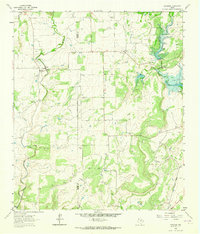
1962 Map of Trickham
USGS Topo · Published 1964About this map
Trickham and Shields anchor this rural Texas landscape where the Coleman Co Brown Co line forms an indefinite boundary through the brush and ranch lands. The map reveals a community defined by its waterways and small, scattered family burial grounds, including Rice Cem and Henderson Cem. Much of the eastern portion of the sheet is marked by the influence of the West Fork Clear Creek, with significant areas subject to controlled inundation. Economic activity in the early 1960s is evidenced by several oil wells, gravel pits, and a gaging station on Mukewater Creek. The presence of an Old Railroad Grade in the southeast corner provides a clear trace of former transit patterns, now replaced by the winding farm roads that connect isolated churches like Mount View Ch to the neighboring settlements.
Find a feature on this map
24 named features on this map. Tap any name to fly to it.
Don’t see what you’re looking for? This feature index may not catch every label — zoom into the map to look around manually.
Map Details
Editions of this 1962 Trickham Map
2 editions found
Other maps of this area

1887 · Coleman
USGS Topo · 1:125,000

1889 · Coleman
USGS Topo · 1:125,000

1894 · Brady
USGS Topo · 1:125,000

1924 · Brady 2-a
USGS Topo · 1:48,000

1925 · Brady 1-b
USGS Topo · 1:48,000

1925 · Brady 1-a
USGS Topo · 1:48,000

1928 · Mercury
USGS Topo · 1:62,500

1928 · Waldrip
USGS Topo · 1:62,500

1950 · Mercury
USGS Topo · 1:62,500

1954 · Brownwood
USGS Topo · 1:250,000