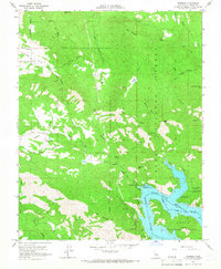
1965 Map of Trimmer
USGS Topo · Published 1967About this map
Pine Flat Reservoir dominates the southeastern terrain of this 1965 survey, where the Kings River is impounded at the meeting point of the Sierra National Forest and Sequoia National Forest. The map provides a unique look at the landscape just after its mid-century transformation; underwater contours from 1948 are included to show the topography as it existed prior to inundation.
Find a feature on this map
48 named features on this map. Tap any name to fly to it.
Don’t see what you’re looking for? This feature index may not catch every label — zoom into the map to look around manually.
Map Details
Editions of this 1965 Trimmer Map
4 editions found
Other maps of this area

1904 · Kaiser
USGS Topo · 1:125,000

1920 · Orangedale School
USGS Topo · 1:24,000

1922 · Trimmer
USGS Topo · 1:96,000

1923 · Orangedale School
USGS Topo · 1:31,680

1924 · Dinuba
USGS Topo · 1:125,000

1942 · Watts Valley
USGS Topo · 1:62,500

1944 · Watts Valley
USGS Topo · 1:62,500

1947 · Mariposa
USGS Topo · 1:250,000

1948 · Fresno
USGS Topo · 1:250,000

1948 · Mariposa
USGS Topo · 1:250,000