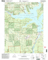
1998 Map of Trinity Dam
USGS Topo · Published 2003About this map
Trinity Dam and its massive Fixed Crest Spillway dominate this late-twentieth-century landscape, where the waters of the Whiskeytown-Shasta-Trinity National Recreation Area have reshaped the terrain. The map captures a complex overlay of modern recreation and older resource extraction, with the Ridgeville site standing as a silent marker of earlier settlement near the Ridgeville Islands. To the south, industrial and institutional presence is noted at the Powerplant and the Trinity River Conservation Camp.
Find a feature on this map
113 named features on this map. Tap any name to fly to it.
Don’t see what you’re looking for? This feature index may not catch every label — zoom into the map to look around manually.
Map Details
Editions of this 1998 Trinity Dam Map
2 editions found
Other maps of this area

1890 · Red Bluff
USGS Topo · 1:250,000

1894 · Red Bluff
USGS Topo · 1:250,000

1913 · Weaverville
USGS Topo · 1:125,000

1944 · French Gulch
USGS Topo · 1:62,500

1948 · French Gulch
USGS Topo · 1:62,500

1950 · Minersville
USGS Topo · 1:62,500

1950 · Schell Mtn
USGS Topo · 1:62,500

1950 · Weaverville
USGS Topo · 1:62,500
1952 · Schell Mtn.
USGS Topo · 1:62,500

1952 · Weaverville
USGS Topo · 1:62,500