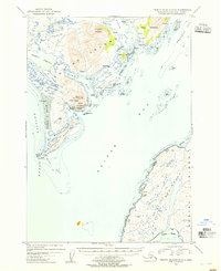
1954 Map of Trinity Islands D-1
USGS Topo · Published 1955About this map
Akhiok stands as the primary settlement on this portion of southern Kodiak Island, situated along the protective waters of Akhiok Bay. The landscape is dominated by a complex network of coastal features, including the sprawling Alitak Lagoon and the rugged elevations of Tungulara Mountain. Commercial activity is centered around the Pacific American Fishery Cannery near Lazy Bay, reflecting the region's mid-century reliance on the sea. The entire land area is contained within the Kodiak National Wildlife Refuge, preserving the relationship between the island's high peaks, such as North Twin Peak and South Twin Peak, and the tidal reaches of Rodman Reach and Moser Bay. Scattered cabins along the shoreline and protected coves like Snug Cove suggest a seasonal or subsistence pattern of life in this maritime environment.
Find a feature on this map
41 named features on this map. Tap any name to fly to it.
Don’t see what you’re looking for? This feature index may not catch every label — zoom into the map to look around manually.
Map Details
Editions of this 1954 Trinity Islands D-1 Map
This is the sole edition of this map. No revisions or reprints were ever made.
Other maps of this area

1951 · Kaguyak
USGS Topo · 1:250,000

1951 · Trinity Islands
USGS Topo · 1:250,000

1951 · Karluk
USGS Topo · 1:250,000

1952 · Kodiak
USGS Topo · 1:250,000

1952 · Kaguyak
USGS Topo · 1:250,000

1952 · Karluk
USGS Topo · 1:250,000

1952 · Trinity Islands D-2
USGS Topo · 1:63,360

1952 · Trinity Islands D-1
USGS Topo · 1:63,360

1952 · Karluk A-1
USGS Topo · 1:63,360

1952 · Kaguyak D-6
USGS Topo · 1:63,360