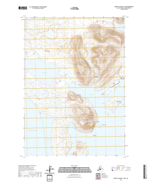
2021 Map of Trinity Islands D-1 NW
USGS Topo · Published 2021About this map
Akhiok sits at the southern end of Kodiak Island, where the landscape is defined by the narrow passage between the Gulf of Alaska and the protected waters of Alitak Lagoon. This survey captures the village infrastructure, including the Akhiok Airport, the Akhiok Cem, and the short stretch of B Street that serves the coastal community. The surrounding terrain is dominated by sharp peaks and jagged shorelines, most notably Tungulura Mtn to the north and the prominent Twin Peaks—comprising North Twin Peak and South Twin Peak—overlooking Kempff Bay. The complex hydrography of the region is evident in features like Sukhoi Lagoon and Lazy Bay, illustrating a maritime environment where water and land are inextricably linked. This map provides a clear record of the area's physical geography, from the heights of Drake Head to the low-lying Akhiok Island.
Find a feature on this map
25 named features on this map. Tap any name to fly to it.
Don’t see what you’re looking for? This feature index may not catch every label — zoom into the map to look around manually.
Map Details
Editions of this 2021 Trinity Islands D-1 NW Map
This is the sole edition of this map. No revisions or reprints were ever made.
Other maps of this area

1951 · Trinity Islands
USGS Topo · 1:250,000

1951 · Karluk
USGS Topo · 1:250,000

1952 · Karluk
USGS Topo · 1:250,000

1952 · Trinity Islands D-2
USGS Topo · 1:63,360

1952 · Trinity Islands D-1
USGS Topo · 1:63,360

1952 · Karluk A-1
USGS Topo · 1:63,360

1952 · Karluk A-2
USGS Topo · 1:63,360
1954 · Karluk A-1
USGS Topo · 1:63,360
1954 · Trinity Islands D-1
USGS Topo · 1:63,360
1954 · Karluk A-2
USGS Topo · 1:63,360